

Ag Weather Forum
Big Storm Potential Next Week
During the fall, it is hard to say which weather conditions would be good for large areas of the country. A lot of the time, it depends on what your operations need, which could conflict with your neighbors.
So, we have to look at weather forecasts as a broader range of impact instead of just saying something like "rain-good" like a caveman. It is more nuanced than that.
With that in mind, drought areas in the western United States and through portions of the Plains and Upper Midwest are still looking for fall precipitation to reduce the drought and establish winter wheat and cover crops ahead of winter, but not so much that it delays corn and soybean harvest or washes away nutrients from too much runoff.
Eastern areas of the country are looking for some rain to keep up soil moisture, but not so much to affect harvest like their western neighbors. But if they stayed dry, it would not be so bad for most areas either. Rain east of the Mississippi has been more abundant even during the last week than off to the west, and has produced some flooding at times, especially recently down in Alabama and Georgia, where dry conditions would be much more preferred on the whole.
Despite the mixed conditions, almost all agricultural activities have been pushed ahead of the average pace for this time in the year. Corn and soybean harvest has advanced to seven and eight percentage points above average, respectively. Winter wheat planting is one percentage point ahead of schedule. But rain across the southern half of the U.S. has delayed the cotton harvest, being seven percentage points behind average.
P[L1] D[0x0] M[300x250] OOP[F] ADUNIT[] T[]
So, an upper-level low over the eastern half of the country that is producing showers through Oct. 8 will be somewhat of a menace, while it would be preferred for many farther west.
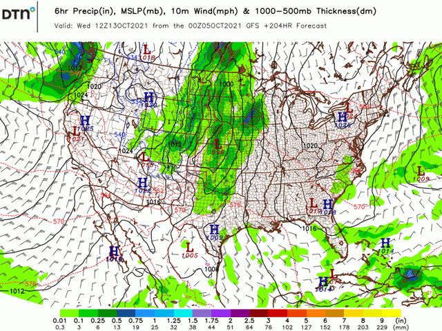
And in short, it looks like there will be some chances as a pattern change comes to the U.S. later this week and through next week. There are a couple of troughs and upper-level lows just making their presence felt along the West Coast as of this writing and those features will move through the western U.S. through the coming weekend. A large reinforcement to the main trough in the West is forecast to build in late this weekend and early next week, building some cold air west of the Rockies.
Each of these features is set to produce at least one storm system. The first couple will be rather weak, but should produce some scattered showers in the Plains and Upper Midwest. The trough that digs into the West next week, however, could produce a really strong system in the Plains toward the middle of next week.
Of course, we are talking about a week in the future, and models have been known to change or develop systems differently as we near the event. However, the stark contrast between a cold trough in the West with a hot ridge in the East sets up a pretty good dynamic for a strong system to emerge out of the Plains and into at least portions of the Midwest.
Strong winds, temperatures dropping significantly, and widespread moderate to heavy precipitation will all be possible with this system and that could have several impacts on activities next week.
If the forecast holds true, we could see significant harvest of corn and soybeans continuing across the Corn Belt in advance of the system as producers race to protect their crop from potential damage from wind or rain, but delay progress when it emerges. Winter wheat planting may also pick up as good soil moisture for the moment could be enhanced next week as well. And there could be some drought reduction for the northwestern Corn Belt where rains have turned lighter during the last two weeks.
Farther east, it is hard to say how the system will develop or affect areas east of the Mississippi River. Models suggest the main forcing moves northward into central Canada instead of pushing eastward, which would limit any impacts from the system. But that would also mean above-normal temperatures and dryness continuing, which would be favorable for harvest. And soil moisture is mostly favorable for winter wheat development, so the rains are not needed from this system just yet.
The other impact that may happen from the system is one I only dare to mention, the dreaded "s-word", snow. The pocket of cold air that will be filling into the Intermountain West will likely be significant. It will depend on how the system wraps up in the middle of next week, but some of the colder weather could make their way into the Plains and if the low is strong enough, could produce some snowfall on its backside.
Now, I hate to mention that, because we are so far out into the future that things can change rather quickly. Being so early in the year, talking about a snow event a week out usually leaves a forecaster with egg on his or her face. But I mention it to describe just how strong this system could be.
It takes some rare conditions to get snow in mid-October, especially after the incredibly hot summer and early fall we have seen already. This system could be one to buck that trend, but it does not look like the start of a period of colder weather. After this system moves through, models point to more ridging, and above-normal temperatures, through the middle of the country through the end of October.
John Baranick can be reached at john.baranick@dtn.com
(c) Copyright 2021 DTN, LLC. All rights reserved.
Comments
To comment, please Log In or Join our Community .