
Ag Weather Forum
Shrinking Ogallala Aquifer
The following article, by science writer Michon Scott, has some stark details of how the Ogallala Aquifer is being drained faster than it is being resupplied. This has some serious implications for the southwestern Plains. The article is adapted from the 2018 Fourth National Climate Assessment. -- Bryce Anderson
**
The Ogallala Aquifer underlies parts of Colorado, Kansas, Nebraska, New Mexico, Oklahoma, South Dakota, Texas and Wyoming. From wheat and cows to corn and cotton, the regional economy depends almost exclusively on agriculture irrigated by Ogallala groundwater. But according to the Fourth National Climate Assessment (NCA4), producers are extracting water faster than it is being replenished, which means that parts of the Ogallala Aquifer should be considered a nonrenewable resource.
P[L1] D[0x0] M[300x250] OOP[F] ADUNIT[] T[]
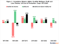
The graphic map shows changes in Ogallala water levels from the period before the aquifer was tapped to 2015. Declining levels appear in red and orange, and rising levels appear in shades of blue. The darker the color, the greater the change. Gray indicates no significant change. Although water levels have actually risen in some areas, especially Nebraska, water levels are mostly in decline, namely from Kansas southward.
In the early 20th century, farmers converted large stretches of the Great Plains from grassland to cropland. Drought and stress on the soils led to the 1930s Dust Bowl. Better soil conservation and irrigation techniques tamed the dust and boosted the regional economy. In 2007, the market value from the Ogallala region's agricultural products totaled roughly $35 billion. However, well outputs in the central and southern parts of the aquifer are declining due to excessive pumping, and prolonged droughts have parched the area, bringing back Dust Bowl-style storms, according to the NCA4. Global warming is likely to make droughts across the Ogallala region longer lasting and more intense over the next 50 years.
The Agriculture chapter of NCA4 describes the risks and opportunities for resilience across the Ogallala region.
Recent advances in precision irrigation technologies, improved understanding of the impacts of different dryland and irrigation management strategies on crop productivity, and the adoption of weather-based irrigation scheduling tools, as well as drought-tolerant crop varieties, have increased the ability to cope with projected heat stress and drought conditions under climate change. However, current extraction for irrigation far exceeds recharge in this aquifer, and climate change places additional pressure on this critical water resource.
More details from the Agriculture segment of the Fourth National Climate Assessment report are at this link: https://nca2018.globalchange.gov/…
Bryce Anderson can be reached at bryce.anderson@dtn.com
Follow Bryce Anderson on Twitter @BAndersonDTN
(ES/)
© Copyright 2019 DTN/The Progressive Farmer. All rights reserved.
Comments
To comment, please Log In or Join our Community .