
Ag Weather Forum
Heat and Dryness in Southern Brazil
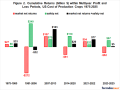
A month of very dry conditions in southern Brazil, now compounded by very hot weather as the Southern Hemisphere summer solstice approaches, is taking its toll on the soybean crop. The second-largest soybean production state, Parana, is being hit the hardest by this dry and now hot pattern. Much of the Parana soybean crop was planted early due to early-season rains; thus, this hot and dry combination is coinciding with the critical pod-filling stage of development. Some crop loss is likely occurring.
It has indeed been very dry in Parana; weather reporting stations in the main production areas of Parana have had December precipitation, through Dec. 17, totaling from 70% to almost 90% below normal.
A geographic feature makes this Parana scenario even more dramatic. The Tropic of Capricorn goes right through Parana. So, as the Southern Hemisphere moves toward its summer solstice this Friday, the sun angle is right on top of Parana -- adding even more intensity to the already hot and dry scenario.
It should be pointed out that this intense hot and dry pattern is not covering the entire extent of Brazil. However, the situation is severe enough that some recent private projections of the Brazil soybean crop reaching 130 million metric tons in 2018-19 are viewed as unlikely to be realized.
P[L1] D[0x0] M[300x250] OOP[F] ADUNIT[] T[]
There are indications of some easing of the exhausting dryness. We do expect to see some significant rainfall and lower temperatures occurring between Friday and Monday, easing crop stress. Also, in far southern Brazil, soybean crop development was not far enough along in Rio Grande do Sul for this heat and dryness to be of any major concern. Scattered showers and thunderstorms though Friday will ease any crop stress in Rio Grande do Sul.
Farther north in Brazil, the Center-West crop region, specifically Mato Grosso, is also having a drier pattern set in. This large production region will have the dry and hot pattern continuing through Friday, followed by scattered showers and thunderstorms and more moderate temperatures during the coming weekend. The recent hotter and drier pattern should not be of major concern to beans as long as the forecast for showers and milder weather verifies.
There are indications that the weather pattern will be turning wetter in central Brazil during the last week of December. This may actually be unfavorable in some areas where harvest has begun.
In central Argentina, scattered showers and thunderstorms have returned after a favorably dry period. This will maintain favorable growing conditions for corn and soybeans. There may be some flooding in the northern half of the region where heavier rains are forecast.
In the U.S., there are still likely some soybeans left in the fields in the Ohio and Tennessee Valleys. Unsettled weather is expected to continue under this pattern, which has the characteristics of an El Nino. Quality issues and some harvest losses are being experienced.
Regarding El Nino: The sea surface temperature departure in the eastern equatorial Pacific for the first half of December was 1.3 degrees Celsius above normal. This is down from the 1.8 C above normal observed during the month of November, but still within El Nino levels.
The atmospheric index of the El Nino event, the Southern Oscillation Index (SOI), is still in a neutral phase.
Michael Palmerino can be reached at michael.palmerino@dtn.com
(ES/)
© Copyright 2018 DTN/The Progressive Farmer. All rights reserved.
Comments
To comment, please Log In or Join our Community .