

Ag Weather Forum
Drought a Problem for Start of Canadian Prairies Growing Season

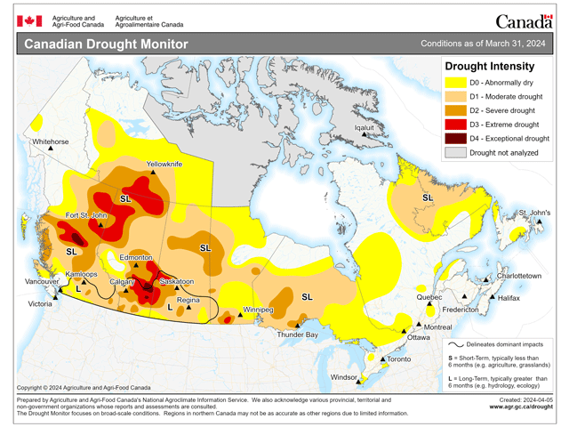
Precipitation over the last six months in the Canadian Prairies has been good for some, and poor for others. Looking at the accumulated precipitation since Sept. 1, the southern half of the region has generally seen near-normal precipitation with pockets of above-normal amounts in southern Alberta. That area has seen a better storm track to build up rain and snow against the Rockies. For these areas, drought on the Canadian Drought Monitor has been reduced by a category or two, but it still remains.
But for portions of southwestern Manitoba, northern Saskatchewan, and northern Alberta, amounts have been less than 85% of normal. And in the case of the Peace region and northern Alberta, those amounts have been no more than 40% of normal in some areas, according to data from Agriculture and Agri-Food Canada that you can find here: https://www.agr.gc.ca/…. Drought here, especially in Alberta, has increased significantly and some areas have seen 3- or 4-class increases in the category of drought over the past six months.
When put all together, drought remains a major force across almost all of the Canadian Prairies' agricultural land -- 99% of which is in some form of dryness or drought and only a small sliver abutting the Rockies west of Edmonton is not featured as an area of drought. The worst drought coverage is in east-central Alberta into west-central Saskatchewan that contains D3-D4 Extreme to Exceptional drought, the two highest categories of drought according to the Monitor.
Recent precipitation events have been trying to do their best, but have not been consistent enough at being able to reduce drought. They have been increasing soil moisture to some extent, however. The warmer-than-normal conditions over the bulk of the winter season have meant that precipitation has quickly soaked into the soils. There is no significant snow cover in any of the region.
P[L1] D[0x0] M[300x250] OOP[F] ADUNIT[] T[]
But that also means that there are no reserves to add to the soil profiles before planting begins this month. The region will be heavily dependent upon consistent rainfall for good agricultural yields and pasture conditions, as well as restocking ponds and reservoirs for livestock.
Luckily, there is some hope on the way as a storm system off the West Coast of the U.S. will combine with a trough that is currently in Alaska to produce a long-lasting precipitation event over the majority of the region next week.
A quick burst of isolated showers will move through April 12-13, but will not mean much. But as the two storm systems combine near the region, precipitation will increase Sunday night into Monday, April 14-15 and the storm system will move in and around the region through April 18 before leaving to the southeast.
An abnormally long-lasting storm system will bring a host of weather conditions to the region, with the main feature of widespread rain changing over to snow, which may be heavy. Winds should be strong and some periods of gusts of 70-90 kilometers per hour (40-55 miles per hour) could create blizzard conditions in the areas of snow.
Speaking of which, snowfall amounts will likely be heavy in some locations, perhaps being widespread. Models disagree on exactly where that will occur, depending on how the storm develops and when colder air moves in, but generally agree that northern Saskatchewan and Manitoba stand the best chance at extreme amounts. Here, totals could reach over 30 centimeters (12 inches). Snowfall amounts are likely to be scattered elsewhere throughout the region and large areas could see more than 10 cm (4 in). Total precipitation amounts will also be variable, but are forecast to be in the 15- to 50-millimeter (0.6- to 2-inch) range, and would account for almost a month's worth of precipitation in some areas. The biggest discrepancy in the models happens to be over the highest drought areas with some saying that central Alberta will get heavy precipitation with others focusing that more into Saskatchewan. We will have to see on that front.
The second piece of the storm from Alaska will provide some very cold air into the region as the week wears on which will be responsible for changing the precipitation over to snow, but will also linger the rest of the week. High temperatures below freezing are likely from April 17-19, and may continue into that weekend where snowfall is the heaviest. The coldest mornings could drop down to minus 15 Celsius (single digits Fahrenheit). Other locations may only see temperatures rising slightly above freezing to melt off some of that snow.
Big storm systems are normal during the spring months, but there probably will not be another that has the intensity or coverage as this storm will for the rest of April and probably May. Models suggest that a trough lingers near the West Coast for May, though. That probably means the storm track will be active through the region for the month, but may not be with sweeping storm systems.
Instead, they would produce piecemeal precipitation events that would be more likely to leave streaks of precipitation across the region instead of large shields. Drought is hard to reduce when precipitation comes in this manner and may worsen drought in some areas while offering relief in others. This may not be the forecast that agricultural producers in the region would like to see, as planting may go well overall, but the more limited soil moisture may run quickly if and when the summer turns hotter.
To find more international weather conditions and your local forecast from DTN, head over to https://www.dtnpf.com/…
John Baranick can be reached at john.baranick@dtn.com
(c) Copyright 2024 DTN, LLC. All rights reserved.
Comments
To comment, please Log In or Join our Community .