
Ag Weather Forum
Active Weather Pattern Not Equal for Canadian Prairies but Continues Next Week

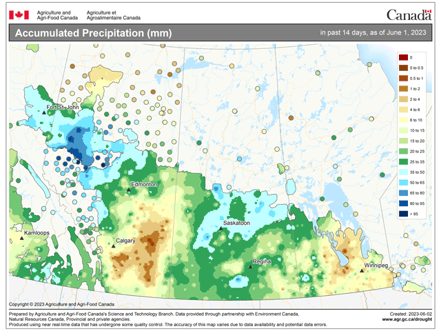
The last two weeks of May have certainly been an active period for the Canadian Prairies. Heavy rainfall over 50 millimeters (near 2 inches) has fallen between May 18-31 across the Peace and northwest regions of Alberta and across parts of Saskatchewan, which does not include some heavy rain that moved through Saskatchewan June 1. That data was not yet available. Large areas of the region have seen increases in soil moisture as a result, benefiting many of the region's drier croplands and pasturelands.
Not all areas have been so lucky, however. Much of central and southern Alberta have only seen light showers with some in central Alberta seeing next to nothing. Parts of Manitoba have been missing out as well, according to analysis from Agriculture and Agri-Food Canada, which you can find here: https://www.agr.gc.ca/….
Temperatures during the last week have been especially warm with daily highs in the middle to upper 20s Celsius (middle 70s to middle 80s Fahrenheit) and Manitoba pushing into the lower 30s (upper 80s to lower 90s F) the last few days. Areas that have been drier are seeing increased stress while those with ample soil moisture are seeing rapid crop and pasture growth.
It has been surprising to see such an active pattern for a relatively long period of time. Usually, these sorts of patterns tend to last only a few days or a week before the atmosphere shifts around.
P[L1] D[0x0] M[300x250] OOP[F] ADUNIT[] T[]
But we have seen a relatively stable ridge of high pressure dominate over much of Canada, especially this week. Normally, that would be a drier look, but weaknesses and disturbances off the coast of British Columbia and the Pacific Northwest have been bringing enough energy to create the showers in the region. They have been largely disorganized and sporadic but have been around.
The pattern changes next week, though, and there will be some change to the weather situation over the Prairies. The ridge that is spread out throughout Canada will retreat westward next week, becoming centered in Alberta by week's end. The shift will allow more disturbances to ride over the top of the ridge and come down through central Canada and the Great Lakes, bringing cold fronts down.
With such warm weather off to the north, the temperature drop will be negligible for most areas. But even with the pattern change, areas of showers and thunderstorms will continue in the region.
At least two fronts will move through next week. One will get hung up across the region early next week, which should continue the rainfall, while another late next week will tend to clear the region out of showers and give a break to the region for a day or two. With any luck, the late-week front will get hung up near the Rockies and continue showers in parts of Alberta into the weekend.
After a two-week period that has been largely beneficial to the region, another week of active weather should be seen as a continued boost to soil moisture and crop development. However, like the previous two weeks, not all areas are going to get hit and not equally either. Thunderstorms have a tendency to put down some significant rainfall, but only localized. Without a real organizing force, even with the fronts moving through, that will still be the case next week. Some areas are bound to miss out while others may potentially flood from continued heavy rainfall.
The heaviest rains are being forecast over Saskatchewan for the next week, while parts of central and southern Alberta have lower chances for widespread heavy rainfall. Mother Nature tends to do whatever she pleases instead of following computer models, though, so the chances that exist may yet hit those needed areas while leaving wetter areas alone.
To find more international weather conditions and your local forecast from DTN, head over to https://www.dtnpf.com/…
John Baranick can be reached at john.baranick@dtn.com
(c) Copyright 2023 DTN, LLC. All rights reserved.
Comments
To comment, please Log In or Join our Community .