South America Calling
Subsoil Moisture Improved, But Insufficient Ahead of Safrinha Corn Planting in Brazil
The first 10 days of January, and the last couple of December, have been a good period of rainfall for much of central and northeastern Brazil. These areas have had continuous dryness and drought issues all season long and forecasts for soybean production have fallen from the record levels forecast at the beginning of the season.
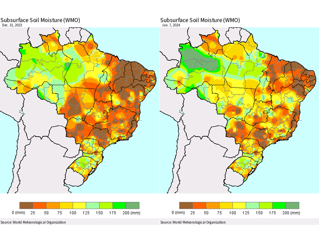
Subsoil moisture continues to be the biggest issue. With inadequate rains to start the season, the holdover from the dry season has meant subsoil moisture levels are very low for much of Brazil outside of the far south, which had flooding issues earlier this season. From Parana northward, only pockets of good subsoil moisture exist, according to the World Meteorological Organization's map of subsoil moisture as of Jan. 7 in the attached image. It has improved significantly over the last week, and this point of the season is the best that subsoil moisture has looked all season long, but it is inadequate for the coming safrinha (second-season) corn crop, which will start to be planted in higher numbers later this month.
Typically, producers in much of Brazil can plant a short-season soybean crop followed by a short-season corn variety to capture the most out of the wet season rainfall that inundates the country between September and May. However, to pull this off, large amounts of built-up soil moisture are required for corn to finish out its grain-filling stages as the wet season rains shut down before the crop can mature. So far this season, the rains have been sporadic. While giving fits to soybeans, rains have come at opportune times in the last month to at least give many areas in the country a shot at good yields. However, it has not been enough to penetrate the subsoils and instead is being used up quickly by soybeans, or evaporated away in the heat that generally peaks in the lower-to-middle 30s Celsius (90s Fahrenheit). When those rains have been absent for a while, those highs peak out closer to 40 C (104 F) and put an incredible amount of stress not only on the plants, but also on the soil moisture.
P[L1] D[0x0] M[300x250] OOP[F] ADUNIT[] T[]
The rainfall over the last two weeks has been able to make some improvement in that subsoil moisture, but only pockets of adequate moisture are currently noted in the state of Mato Grosso east through Bahia and Minas Gerais. This general area accounts for more than 60% of the soybean and corn production in the country and the limited soil moisture. Some areas farther south have not had the heavy rains this month until just the past couple of days. The states of Mato Grosso do Sul, Sao Paulo, and Parana account for approximately 25% of the soybean and corn production in the country and have had little rainfall since early December. Subsoil moisture here is in much worse condition and will need some increase soon to save more of the soybean crop and prep soil for the coming safrinha season.
Soybean harvest has started in the states of Parana and Mato Grosso and reports out of both states are for lower yields compared to average, including some areas of devastating losses where heat and dryness were most intense.
The forecast for the next few weeks offers some hope for these southern areas to continue to support filling soybeans and start building important soil moisture. Ten-day totals from the European ECMWF model show widespread areas of 50-100 millimeters (roughly 2-4 inches) as several waves of showers move north from Argentina. Additional rainfall is forecast in the medium range through the end of the month on the order of another 40-75 millimeters (roughly 1.5-3 inches); that should help as well.
Farther north, it is a little more concerning. Though scattered showers look to remain out in Mato Grosso through the weekend, the coverage elsewhere has died off and Mato Grosso will likely follow suit next week as well. Through the same 10 days, amounts across the region are looking to be less than 30 millimeters (1.2 inches) in most of the eastern areas, and 20-50 millimeters (0.8-2 inches) farther west. That is probably enough to sustain a crop, but the momentum for building soil moisture in the region may halt. If there is some good news for producers there, the following week looks better as rains spread from southern Brazil into central and especially northeastern areas. Models are putting down another 30-75 millimeters in the west but 50-100 millimeters in the east. Areas that will be seeing the lowest rainfall in the next 10 days should end the month with some good totals.
The up-and-down weather is not favorable for sustaining good conditions for the current crop or preparing for the coming safrinha crop, either. How February and March turn out will be instrumental in the safrinha corn production for this season. If wet-season rainfall can overperform, there is support for a good corn crop. If it disappoints, there could be larger concerns. For what it is worth, the current DTN forecast has near- to above-normal rainfall for most of Brazil in February, but near- to below-normal rainfall in March for central Brazil, and near- to above-normal rainfall in southern Brazil.
To find more international weather conditions and your local forecast from DTN, visit https://www.dtnpf.com/….
John Baranick can be reached at john.baranick@dtn.com.
(c) Copyright 2024 DTN, LLC. All rights reserved.


Comments
To comment, please Log In or Join our Community .