

South America Calling
Another Round of Frost and Freezes for Southern Brazil

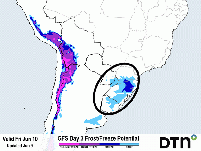
For South America, La Nina brings a whole host of weather issues for those trying to produce crops to feed the world. This weekend it is in the form of frost. A frost event occurred in mid-May, but was very isolated where corn was growing in the state of Parana. The forecast for this coming weekend looks much more menacing as cold air finally pushes a stalled front northward.
That front has been stuck around southern Brazil and Paraguay for about two weeks. Being only occasionally active and waffling around a bit, the showers have been rather good for immature corn and vegetative wheat in the region. Flooding has not been a large issue even with the long stretch of rains. Instead, safrinha (second-season) corn has maintained good quality, at least according to the state of Parana.
P[L1] D[0x0] M[300x250] OOP[F] ADUNIT[] T[]
Conditions have slipped a bit from the near-perfect reports back in early May, but 80% of the corn is rated as good to excellent. But the state also notes that only 26% of the crop is mature with less than 1% being harvested as of June 6, so there is still a way to go until the end of the season. Harvest usually begins in earnest in late June or early July depending on planting date. This year will come earlier, but with so much of the crop still trying to finish out, corn is still susceptible to frost damage.
This time around, the frost threat looks much more widespread. Cold air, which has been producing light frosts in Argentina all week, is pouring northward with a colder lobe of high pressure on June 9. While some frosts may occur on June 10 across the southern-most state of Rio Grande do Sul in Brazil, it is during the weekend that frost becomes more likely. Skies will clear and winds will go calm under the dome of high pressure, perfect conditions for radiating heat away from the surface and producing frosts. Low-lying, exposed areas will have the greatest threat. In addition to Rio Grande do Sul, Parana and southern Mato Grosso do Sul look most likely to observe freezing temperatures and it may be possible for another morning of frost on June 13 before the high-pressure center moves off the coast and temperatures moderate.
The risk of frost damage may not be as great as the events that occurred in 2021, as much more of that crop was immature compared to the current situation. But with 70% to 75% of the crop still to reach maturity, some damage is likely to occur. The more widespread the frost gets, the more of an impact it will have on the safrinha corn production in this part of the country.
In other news, the front moving into central Brazil during the next several days might have been a good thing if it had happened a month or two ago, but with more than 6% of the crop already harvested in the state of Mato Grosso as of June 3, this crop is too far along to be able to use the incoming moisture. As the front pushes northward, its ability to create showers will weaken and showers are not likely to get much farther north than the southern borders of Mato Grosso, Goias or Minas Gerais. If the showers would have been helpful, they likely would not have fallen for a good enough portion of the crop.
To find more international weather conditions and your local forecast from DTN, head over to https://www.dtnpf.com/…
John Baranick can be reached at john.baranick@dtn.com
(c) Copyright 2022 DTN, LLC. All rights reserved.
Comments
To comment, please Log In or Join our Community .