

South America Calling
Scratch That: Wet Season Likely Delayed for Central Brazil
Last week it looked like there were some model differences suggesting the wet season might start in central Brazil on the early side as opposed to a typical delayed start we saw with other models and especially due to the developing La Nina.
Below normal ocean temperatures in the Pacific typically slow down the International Tropical Convergence Zone (ITCZ) from diving south through Brazil on its normal schedule. Information from USDA Meteorologist Mark Brusberg suggests its arrival is about a week short on average; but that is not always the case and it is sometimes much later. The ITCZ spreads tropical moisture into central Brazil in late September, starting its wet season that lasts until early May before it moves back into the Northern Hemisphere.
P[L1] D[0x0] M[300x250] OOP[F] ADUNIT[] T[]
La Nina has a twofold effect in most years. It shortens the wet season by delaying its start date and hastening the end date, typically by another week. Last season, which was a La Nina event, the wet season was shortened by some five to six weeks. This did not have a significant impact on the main soybean crop but had a dramatic impact on the second-season corn crop. Right after planting finished, the rains essentially shut off, causing the crop to rely mostly on stored moisture for the entire growing season.
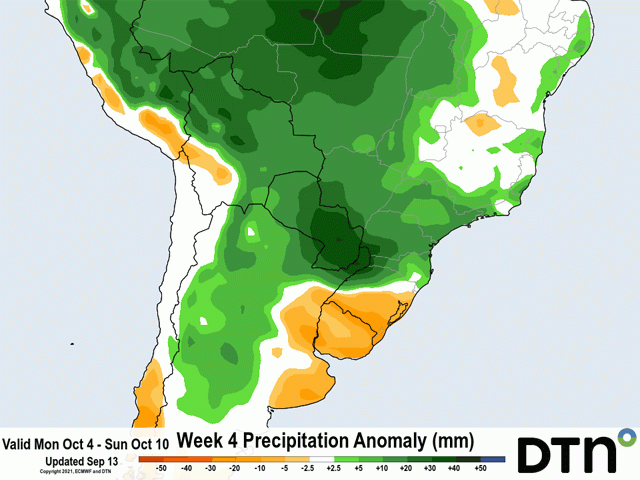
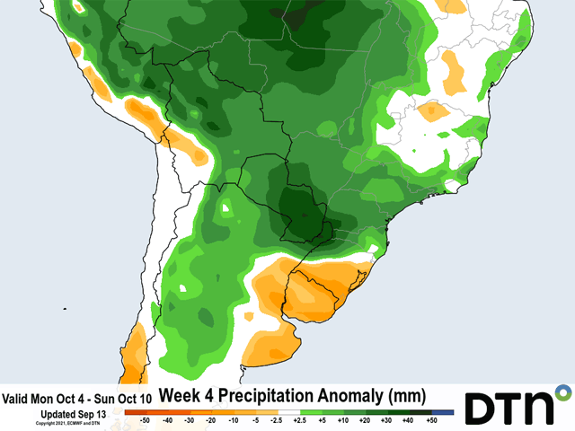
Models are suggesting now that the wet season will be delayed past the average start date of Sept. 26. It is variable across central Brazil, but the end of next week or the following week should be the start. Both the European ECMWF and American GFS now have the end of their model runs going into the end of September, so we can start to look at them for clues. Both show some shower activity over Mato Grosso into Goias around Sept. 26 as a front slides north into the region, which could officially start the wet season if around 30 millimeters (1.2 inches) of rain falls at that time. However, the ITCZ is still a couple of hundred miles off to the north of these areas and would likely take another week or so to migrate farther south.
Models agree and medium-range versions of the European and American models are pointing to near- to above-normal precipitation for the first full week of October, which would be only a slight delay of about one week and typical for La Nina.
The delay will still push back safrinha corn planting by at least that week. Producers usually follow their soybean combines with corn planters in the late summer and early fall. That helps them stay within their optimum planting window and get the seed in the ground with enough time to get through pollination before the dry season begins and the rains shut down.
Like I mentioned earlier, La Nina typically ends the wet season early, leaving producers little margin for error on their safrinha corn crop. Last year was rough and remains on the minds of many producers. Worries are now renewed with the expected delays and the timer starts ticking to see how long it may take to get the beneficial rains into the country. Models have been wrong before; they'll be wrong again. Producers in central Brazil are hopeful the delays are short -- as models are now suggesting.
John Baranick can be reached at john.baranick@dtn.com
(c) Copyright 2021 DTN, LLC. All rights reserved.
Comments
To comment, please Log In or Join our Community .