

Canada Markets
Prairie Precipitation by Location
In the June 9 DTN Market Weather Video, Senior Ag Meteorologist Bryce Anderson pointed to the old saying that "rain makes grain" as one factor behind the view of weather acting as a bearish market factor for the grains on Tuesday.
Weather remains a variable factor on the Canadian Prairies, as some areas continue to lack needed precipitation, while other areas are receiving excessive amounts. Agriculture and Agri-Food Canada's Accumulated Precipitation map for the seven days ending June 8 shows south-central Saskatchewan, the area most in need, falling short over the past week with as little as 4-5 millimeters of precipitation received in some areas.
Meanwhile, an equally large area stretching from northwest Saskatchewan and across the northern areas of Alberta are shown to have received 65 mm or more. A small area in southeast Manitoba also received 65 mm or more.
P[L1] D[0x0] M[300x250] OOP[F] ADUNIT[] T[]
AAFC's Percent of Average Precipitation map for the April 1-through-June 8 period shows the driest areas of the Prairies surrounding Regina, Saskatchewan have received less than 40% of average precipitation, while the wet areas in northern Alberta have seen from 150% to 200% of normal, with smaller areas having seen 200% or more of normal amounts.
DTN's Market Weather Video points to a warm trend in the northwest U.S. also moving from west to east across the Prairies. DTN's 5-Day Highs Compared to Normal chart shows highs to range from mostly zero to 3 Celsius across most of Saskatchewan and Alberta during the next five days ending June 13. The exception is a small area along the Saskatchewan-Alberta border in southwest Saskatchewan where highs could range from 4-6 degrees C above normal. Following recent rains, this heat will promote active plant growth. The exception is Manitoba, where highs are forecast to reach zero to 3 degrees C below normal.
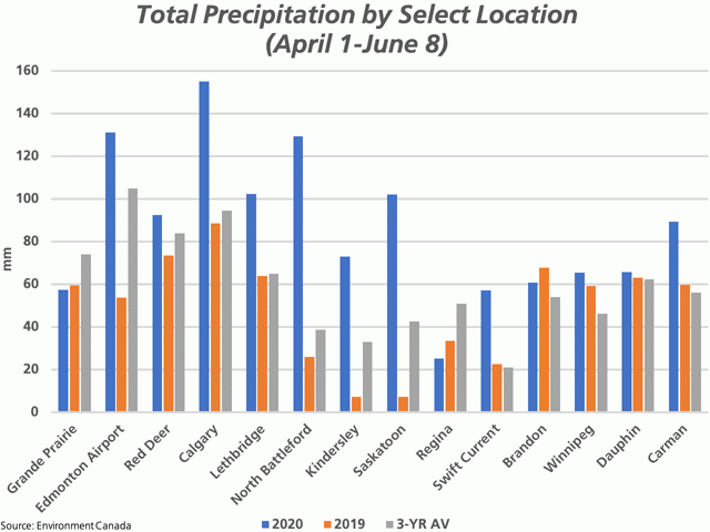
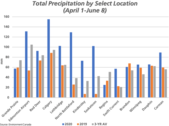
The attached chart shows total precipitation received from April 1 through June 8 for select locations across the Prairies, based on Environment Canada historical data. While almost all locations are showing total precipitation received over this period above the three-year average, the increase (blue line compared to the grey line) is much more noticeable in the western Prairies, or given the selected locations, from Saskatoon and points west. Grande Prairie is one exception, with reported precipitation over this period below the same period in 2019 as well as the 2017-2019 average.
Many areas have seen the best start in four years. Two locations checked are Kindersley and Swift Current that fall into this category. April 1-through-June 8 precipitation for Kindersley at 72.8 mm and Saskatoon at 102.1 mm compared to just 7.2 mm for the same period in 2019 at each location, when germination got off to a slow and patchy start.
While not shown on this chart, the town of Athabasca, Alberta has received 159 mm over this period, just one location in the northern areas of Alberta where spring planting will be jeopardized.
Cliff Jamieson can be reached at cliff.jamieson@dtn.com
Follow Cliff Jamieson on Twitter @Cliff Jamieson
© (c) Copyright 2020 DTN, LLC. All rights reserved.
Comments
To comment, please Log In or Join our Community .