


Ag Weather Forum
Big System Moving Through US Next Week Could Cause Widespread Fieldwork Disruption
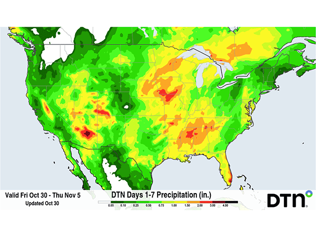
Producers have been enjoying a rather nice stretch of weather to catch up on fieldwork that had been bogged down from heavy rain back in September and early October. While corn harvest is still a few percentage points behind schedule as per the latest NASS Crop Report through Oct. 25, soybean harvest and winter wheat planting have caught up to the normal pace. And good weather this week likely accelerated those efforts, especially when producers look at the weather forecast for the next week that features a lot of rain and a big storm system.
Ahead of that storm system, showers are increasing across the middle of the U.S. through the weekend. A plume of tropical moisture moved north out of Mexico and into Texas on Thursday, Oct. 29. Some of that moisture has already found a stalled front across the Iowa-Missouri border area and is producing showers as well. The showers will continue there into the weekend while the tropical moisture will become more diffuse as it moves north and east across the country through the weekend. Still, some areas of moderate-to-heavy rain will occur, sending equipment back inside while producers wait for another stretch of dry weather. Around Texas, Iowa, and Illinois have the best chances at that.
However, a bigger system will be moving through the country that will create widespread moderate-to-heavy precipitation that should create more delays to what remains of fieldwork. Though showers are developing across the Southwest on Friday, Oct. 30, the actual system remains over the Pacific Ocean. That will move onshore into California on Sunday, Nov. 1, quickly moving through the Western U.S. It should move into the Plains on Monday, Nov. 2 with widespread showers and some thunderstorms from Canada down to Mexico before traversing east through the country for the rest of the week. Some slow movement of the system could create three or four low-pressure centers as the system moves through, enhancing showers in various areas of the middle of the country before moving through the Northeast the following weekend, Nov. 7-8.
P[L1] D[0x0] M[300x250] OOP[F] ADUNIT[] T[]
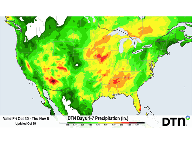
Some of the precipitation is likely to be heavy. When combined with the weekend showers, widespread rainfall amounts of 1 to 2 inches are forecast for vast areas of the country. Only areas in the Pacific Northwest are forecast to miss out on most of this precipitation, though some pockets of drier conditions are to be expected across the country. Even so, areas of heavier-than-forecast rain should be expected as well. Where some rain this weekend coincides with next week's storm, amounts should be enhanced. Pockets of 2 to 4 inches of rain will be possible in some areas because of thunderstorms, some of which may also become severe.
The Storm Prediction Center is already focusing on an area of the Central and Southern Plains for severe potential on Monday, with discussion about potential severe storms in the South and Southeast for Tuesday through Thursday. Damaging winds are the most likely form of severe weather with such a dynamic system, but tornadoes could also be a possibility, especially on Monday.
As this system moves into the Plains on Monday, winds around the system are forecast to increase and could be quite strong. Models are still trying to figure out just how strong this low-pressure center will be on Monday and Tuesday across the Plains, Midwest, and Delta, but are currently putting out around 35 to 45 mph gusts for large areas of all three regions. It is likely that winds will be even stronger in the Central Plains on the backside of one of the low-pressure centers. That is still being determined but could cause some areas of damage.
Any disruptions to fieldwork that occur over the next week are likely to be short-lived though. The weather forecast for behind the system does include some cooler air, but generally sunny and dry conditions. An additional system may follow across the southern tier of the U.S. next weekend, but models are not currently developing this system into anything strong or of much consequence.
On the more positive side, the widespread precipitation over the next week should improve soil moisture for winter crops and help to reduce the widespread drought that continues to show up on the U.S. Drought Monitor across widespread areas of the West, Plains, and Southeast. Some areas of the Delta, where storm systems have largely been missing for the last several months, are in deep D3-D4 drought and need a lot of rain. One storm that produces two weeks' worth of rain will not make much of a dent. But this should be a more active pattern through the winter that favors the southern U.S. thanks to the ongoing super El Nino in the Pacific Ocean.
To stay up to date with weather conditions and your local forecast for free from DTN, head over to https://www.dtnpf.com/…
John Baranick can be reached at john.baranick@dtn.com
(c) Copyright 2026 DTN, LLC. All rights reserved.
Comments
To comment, please Log In or Join our Community .