



Ag Weather Forum
Water Levels on Lower Mississippi River Starting to Run Low Again
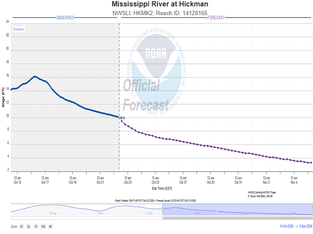
With all the rain occurring across a lot of the U.S. over the last six weeks or so, what has been getting lost in the shuffle is the growing drought in the south-central U.S. Building drought in this region is the primary cause for water levels on the Lower Mississippi River to start running at their lowest point of the fall season, but even the rivers that feed it are running lower as well. This could have implications for transportation up and down the river in the coming weeks.
Rain has been very frequent from the Four Corners area through the Northern and Central Plains, much of the Midwest, and into the Northeast over the course of the fall season so far. That has resulted in reduced drought coverage and intensity since the beginning of September. But systems have regularly bypassed the south-central states. From eastern Texas and Oklahoma through the Lower Mississippi Valley and into the Tennessee Valley, rainfall has been much less frequent, and in some cases, nearly non-existent over the same time period. This has impacted parts of the Lower Ohio River Valley around southern Illinois and Indiana as well. The latest U.S. Drought Monitor, released this morning, Oct. 22, showcases widespread D2-D3 drought in these areas. Some pockets of D4 drought -- the worst classification of drought -- exist there as well.
While the drought has made for easy and rapid harvest conditions, it is starting to significantly impact water flows on local streams and rivers. The Arkansas River runs through this drought-stricken area and is at the lowest streamflow of the season where it meets the Mississippi. Though the Red River doesn't technically flow into the Mississippi, it is also seeing some of the lowest streamflow of the season so far. Even managed and locked rivers like the Cumberland and Tennessee are seeing low streamflow, causing the Ohio River to be already near the low-water threshold at Shawneetown, Illinois.
P[L1] D[0x0] M[300x250] OOP[F] ADUNIT[] T[]
And despite the heavier precipitation flowing into them, even the water levels on the Mid-Mississippi River, north of the confluence with the Ohio, are running lower. At St. Louis, the Mississippi River is at the lowest point thus far this fall, forecast to reach the low-water threshold in early November. That is true for most of the Missouri River up to at least Sioux City, Iowa. Even after this portion of the river experienced flooding during the first few days of October.
With the lack of water flowing into the Lower Mississippi, and the ongoing drought, water levels on the major transportation route down to the Port of New Orleans are at risk of running low again for the fourth-straight fall. Current forecasts just south of the confluence of the Mississippi and Ohio Rivers at Hickman, Kentucky, show water levels on the Mississippi River getting down toward the low-water threshold in the first few days of November. It will take some time for that to translate downstream, but water levels in early November in Memphis are forecast to close in on minus 5 feet by Nov. 5. The low-water threshold is minus 8 feet. It would take until mid-November to get down toward the low-water threshold in Greenville, Mississippi.
The U.S. Coast Guard changes rules for how much traffic and how heavy barges can be when transporting up and down the river. When water levels are too low, restrictions on barge weight and draft limit how much can be transported, increasing costs. Producers in the interior of the country can expect lower futures prices and basis when this occurs.
The only thing that could stop the water levels from falling to the forecast would be significant rainfall. Through the end of October, very little precipitation is forecast across the primary Mississippi River Basin. A system will bring scattered showers into the Northern Plains on Friday, a stalled front will bring showers to the Central Plains and Upper Midwest this weekend, and another system will move from the Central Plains through the Midwest early next week. Another system may be possible later next week that could bring through some isolated showers as well. Though any rain will help areas locally, it is not forecast to produce much runoff moving through the river system in a short period of time. Therefore, the current river forecasts are likely to be accurate. The weather pattern may change in November though. Mid- to long-range weather forecasts have a pattern that would favor more active weather across the southern tier of the country in early to mid-November. If that verifies, there could be some precipitation that would help to ease the ongoing drought in the South-Central, and perhaps boost water levels on rivers that feed the Mississippi. Until then, preparations for restricted travel on the Mississippi should be expected over the coming weeks.
To stay up to date with weather conditions and your local forecast for free from DTN, head over to https://www.dtnpf.com/…
John Baranick can be reached at john.baranick@dtn.com
(c) Copyright 2026 DTN, LLC. All rights reserved.
Comments
To comment, please Log In or Join our Community .