

Ag Weather Forum
Series of Storms Bring Areas of Heavy Rain, Possible Snow This Week
A big upper-level trough that moved into the West this weekend will change the pattern this week as it sends multiple pieces of energy eastward. The trough will push out a stagnant ridge that has kept much of the country east of the Rockies with above-normal temperatures in the last two weeks.
This ridge has been anchored over the middle of North America since early last week and still holds on. Temperatures underneath the ridge are 20-25 degrees Fahrenheit above normal for early February in the Upper Midwest and significantly above normal elsewhere as well. The warmth in the Upper Midwest has already been record-breaking for a few days and will continue that trend for the next couple until the western trough starts to take over the pattern.
That trough is already responsible for a huge deluge of rain in California. As of early Tuesday morning, Los Angeles International Airport has recorded over 4.5 inches of rain while other parts of the region saw more than 7 inches. The region averages just 14 inches of rainfall a year, which means that some areas have already seen half of a year's rainfall in just two days. San Francisco recorded close to 2 inches of rain, half of a normal February's total. Flooding has been a major concern in the region. Snowfall in the Sierra mountains has been measured in feet with the reports from this storm clocking in at 2-3 feet so far, along with similar amounts from a storm last week.
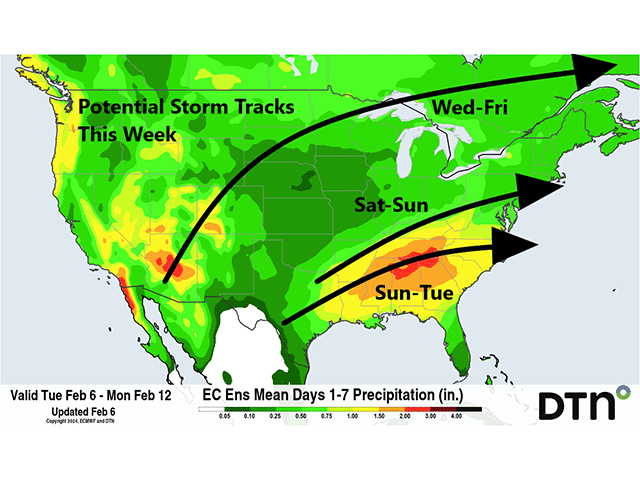
That trough will be on the move and push out the warm ridge later this week. That first punch from the trough will be moving northeast on Tuesday and get into the Northern Plains on Feb. 7. The low will track from Nebraska into northern Minnesota by Thursday evening with the low continuing through Ontario on Friday. Scattered showers will concentrate near and north of the low's track, but scattered showers and some thunderstorms will be possible across much of the Central Plains and Midwest with this first impulse.
P[L1] D[0x0] M[300x250] OOP[F] ADUNIT[] T[]
On the northwestern side of the low, it will be just cold enough to turn rain over to snow and some heavier amounts will be possible in Montana and western and northern North Dakota. Light snow will continue to wrap around on the backside of the low-pressure center on Friday across the northern Midwest but should be rather light. In the heavier band, 3-6 inches of snow appear likely.
This system will lay down a cold front from the Southern Plains into the Northeast for the later portion of the week and that should be active with showers developing along it. A little impulse will ride along the front and bring more rainfall from Texas into the Mid-Atlantic for the weekend. And then one final system will develop over Texas on Sunday and move through the Southeast for Monday and possibly into Tuesday with another round of showers.
Where these storm systems overlap, precipitation will be maximized. For those in the Delta and Tennessee Valley, that could mean over 2 inches of rain. These areas are still dealing with long-term deficits and drought and will be happy to see more rain falling. Other areas from Kansas up through Minnesota and Wisconsin are have long-term deficits, though that has been mitigated during the winter. Still, the storm track will go around these areas with little chance for improvement in the long-term deficits. You can read more about the impact of the wintertime rainfall here: https://www.dtnpf.com/….
Models have this southern precipitation from the second two pieces falling mostly as rain. While very warm weather is going to be felt ahead of the first system, it does cool off significantly behind the last one. Temperatures will fall some 20 degrees F. That could be just cold enough for snow in some of these places where the rain moves through but it is still borderline.
For now, the Southwestern Plains and the Central Appalachians are favored with the third storm, but that forecast can change. However, even though these temperatures will fall behind the storm, a rush of cold air is not in the forecast at least for next week.
Still, the pattern is shaping up to give some potential for colder air to sneak down into the U.S. later next week and through the end of February and early March as well. The trough will take over the Eastern U.S. for next week and another ridge will be popping up in Western Canada. That is a decent setup to bring in at least seasonably colder air behind a few little clipper systems and we'll watch for that.
We will also look for some potential to squeeze off a piece of the polar vortex later this month that could bring some colder air into the picture for the last few days of the month into early March. While models do not currently indicate any significant cold, they may not be seeing the full picture just yet.
To find more weather conditions and your local forecast from DTN, head over to https://www.dtnpf.com/…
John Baranick can be reached at john.baranick@dtn.com
(c) Copyright 2024 DTN, LLC. All rights reserved.

Comments
To comment, please Log In or Join our Community .