

Ag Weather Forum
Mid-July Rains for the Southern and Eastern Corn Belt

The latest Crop Progress report released by the USDA on Monday shows a clear picture of the lack of moisture and its effects on crops in the heart of the Corn Belt.
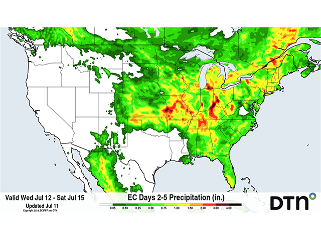
Illinois has 39% of its corn crop rated in good or excellent condition for the week ending July 9. Meanwhile, Missouri's corn condition ratings show an even worse rank, with only 25% of its corn crop rated in good or excellent condition. While both states have seen sporadic rain showers and thunderstorm complexes roll through in the past few weeks, the adequate subsoil moisture is not widespread. Forecast rainfall through July 15 paints a more promising picture, where some improvements to soil moisture could be seen in areas across the southern and eastern Corn Belt.
A trough in south-central Canada is causing the active weather pattern across the north-central United States this week. On both sides of this Canadian trough sit two ridges, one extending across the Canadian Rockies to the west, and the other parallels the east coast of Canada. These two ridges are blocking the trough from advancing east and the only way for this trough to advance east is for the ridge in eastern Canada to weaken. Therefore, this trough is forecast to park itself in south-central Canada into the upcoming weekend before it will finally start to shift east early next week as the ridge in eastern Canada loses strength.
P[L1] D[0x0] M[300x250] OOP[F] ADUNIT[] T[]
The Canadian trough is the main reason why there will be multiple chances for rain into this weekend across the Corn Belt. A cold front from a low-pressure system that has been rotating around the trough has led to scattered rain showers and thunderstorms across the Northern Plains and Upper Midwest on Monday. This cold front will drop south on Wednesday and lead to shower and storm development across the southern and eastern Corn Belt. In addition to this cold front, a low-pressure system from the Intermountain West will form along the front and provide more moisture to the southern and eastern Corn Belt late this week and into early this weekend.
With the expected rainfall comes the chance for thunderstorms as well. On Wednesday, the Storm Prediction Center has a slight risk for severe thunderstorms across southern Iowa, most of Missouri and Illinois, as well as western Indiana. The atmosphere will likely become unstable across Missouri late Wednesday and models are hinting at the potential for a strong thunderstorm complex to form across northwest Missouri Wednesday evening and advance southeast early Thursday morning. While a few tornadoes and damaging hail will be possible with thunderstorms on Wednesday, strong to severe thunderstorm wind gusts will also be a main threat. If this thunderstorm complex develops as some models suggest, wind gusts up to 75 mph could be possible across northern Missouri Wednesday evening.
While damaging hail, wind gusts and tornadoes are not ideal for the maturing crops across the Central Mississippi Valley this time of year, the potential rainfall is. The European Centre for Medium-Range Weather Forecasting (ECMWF/European) model suggests that pockets of one to three inches of rain could fall across Missouri, Illinois, Kentucky and Ohio from Wednesday through Saturday. More isolated spots across these states could even see rainfall totals approach four inches if multiple rounds of rain target the same area through Saturday. This would certainly benefit maturing corn and soybeans across these states and reduce some of the recent stress they've seen from the lack of adequate topsoil moisture.
On the flip side, there will be areas that miss out on one to three inches of rainfall over the coming days. These may be areas that already lack sufficient subsoil moisture to keep the crops going as they begin their reproductive stages. Those that miss out on the more measurable rainfall over the coming days may continue to take hits to their crop yields. It will again be the case of the haves and have-nots, as some producers will receive the needed rainfall, and some will be left mostly dry. We will have to see how the rainfall and storm complexes develop in the coming days and hope for some improvement in corn and soybean conditions come the next USDA Crop Progress report on July 17.
To find more weather conditions and your local forecast from DTN, head over to https://www.dtnpf.com/…
Teresa Deutchman can be reached at teresa.deutchman@dtn.com
(c) Copyright 2023 DTN, LLC. All rights reserved.
Comments
To comment, please Log In or Join our Community .