

Ag Weather Forum
Similar August Weather Years Point to Dry Late Summer
The first full week of July brought some rain to portions of the northern and central U.S. Fields receiving rain--and not its more-solid counterpart, hail--had improvement in soil moisture for crops, pasture and livestock water supply. There's no doubt that the moisture was needed; after all, corn tassels are just now appearing in many areas, to be followed shortly by pollination. In addition, soybean plants are getting into the time for blooming and setting pods. The serious business of determining this year's yield is getting underway, and big yields demand moisture.
However, indications are that follow-up rainfall during the rest of July and through August may be a tall order to fill. One signpost in the forecast arena that points to this less-than-ideal trend is how analog weather years are leaning. The U.S. National Oceanic and Atmospheric Administration (NOAA) defines "analog" as: "A historical instance of a given meteorological scenario or feature that is used for comparison with another scenario or feature. For example, a long-range forecaster predicting conditions for the upcoming winter may make comparisons to analog seasons in which meteorological factors were similar to those of the upcoming season."
That methodology along with modern computer capability have allowed the DTN long-range forecast team to develop an in-house analog year array that has some concerning elements for crop weather in anticipation of late summer.
P[L1] D[0x0] M[300x250] OOP[F] ADUNIT[] T[]
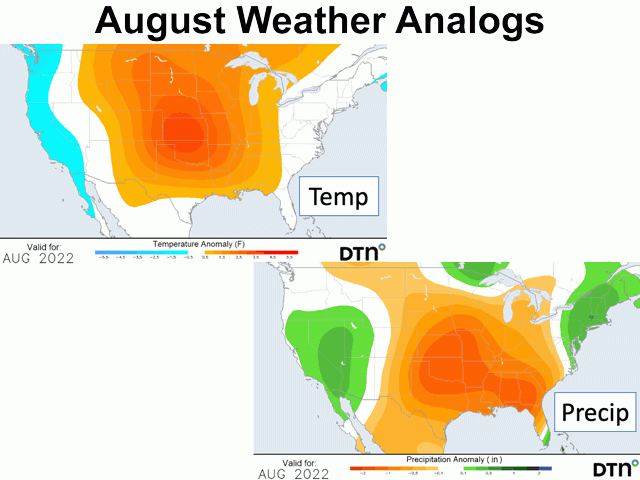
Looking to the month of August, the DTN analogs point to temperatures running either above or much above normal from the Rocky Mountains to the Ohio Valley west to east, and from the Canadian Prairies to the Gulf of Mexico north to south. Territory covered takes in the entirety of the Great Plains and almost all the Midwest except for a sliver in the eastern part of the region.
Correlating with the above-normal temperatures, precipitation in the DTN analog composite has a dry trend--below normal over almost the exact coverage spread as the temperature forecast. The only exception in possible crop areas is a small slice of the northern Great Lakes with near to above normal amounts.
To produce the analog reference graphics, DTN's long-range forecast team took the following years into consideration due to their general resemblance to what we have seen so far in 2022. Those years are: 2011; 2010; 2020; 2008; and 1950. These are the strongest years in the analog preparation at this point in the season. These years are all La Nina years with a notably cool ocean temperature pattern in the equatorial Pacific Ocean. The first three years noted -- 2011, 2010 and 2020 -- are also years when mid to late summer heat and dryness shaved crop yields to at least some extent. And, in the case of 2020, the summer brought the devastating derecho to the western Midwest.
Analog years by themselves do not make a forecast. Nonetheless, the suggestion from what we have at this point in the 2022 crop year does bring caution into thinking about how this season's production will actually play out.
Bryce Anderson can be reached at Bryce.anderson@dtn.com
Follow him on Twitter @BAndersonDTN
(c) Copyright 2022 DTN, LLC. All rights reserved.

Comments
To comment, please Log In or Join our Community .