

Ag Weather Forum
Windstorm and Severe Weather Blow Through Plains, Midwest
Only a few days after an already anomalous system went through Dec. 10-11, another incredibly strong and unusual storm system moved through the country. I already recapped the first storm here: https://www.dtnpf.com/….
Just a couple of days later, a trough of low pressure moved into the Western U.S. where widespread precipitation helped to ease some of the drought, but also caused a multitude of winter weather advisories, storm warnings and high wind impacts. But the true strength of the system occurred after it crossed the Rocky Mountains.
Temperatures out ahead of the system were once again very high. In fact, there were widespread records broken both for the day and the month of December from Texas all the way up to Wisconsin. In several of these instances, the records were completely smashed by 10 to 20 degrees. For example, by rising up to 74 degrees Fahrenheit, Omaha, Nebraska, beat its all-time December high by just 2 degrees but smashed its daily record by 15 degrees. Waterloo, Iowa, is the most extreme example. By reaching a high of 74 degrees, it beat its all-time December record by 7 degrees and its daily record by 20 degrees. Other official climate sites throughout Iowa and southern Wisconsin had similar results as warm air raced northward due to strong winds.
P[L1] D[0x0] M[300x250] OOP[F] ADUNIT[] T[]
Speaking of those strong winds, ahead of the system, winds were gusting on the order of 30 to 40 miles per hour (mph). That was not an atypical windy day in the Plains or western Midwest. However, as the system moved east of the Rockies, it rapidly strengthened and deepened, causing winds to rush even faster. Widespread wind gusts over 70 mph were recorded from Amarillo, Texas, up to Rapid City, South Dakota, and then eastward through almost all of Nebraska and Kansas, western Iowa and northwest Missouri. Other wind gusts exceeding 50 mph were recorded elsewhere throughout the Plains and the northwestern half of the Midwest.
Winds in the Central Plains made for incredible video. Aided by the dryness and drought, dust was easily picked up by the strong winds and blown vast distances. During the afternoon, it was easily visible on satellite imagery. It will still need to be assessed whether the erosion caused significant damage to winter wheat in the region.
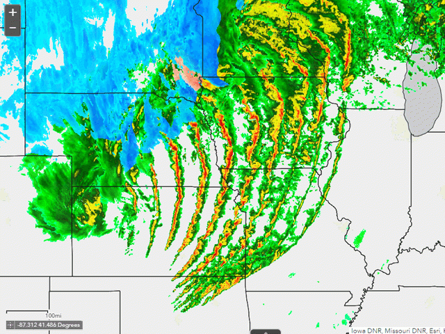
Some of those wind gusts were aided by yet another round of severe December storms. In contrast to the severe event that unfolded in the Midwest and Midsouth five days earlier, severe storms occurred with one broken line.
Storms started to develop early in the afternoon across south-central Nebraska and north-central Kansas. The line expanded north and south as it moved rapidly northeast through the afternoon and evening hours. Extreme wind gusts and several tornadoes developed along the line. As of the morning of Dec. 17, there were 32 reports of tornadoes and 552 reports of wind damage from the thunderstorms alone. There are likely to be more tornadoes confirmed as crews survey damage. Among those are the first December tornadoes ever in the state of Minnesota. And the 61 reports of significant wind gusts over 75 mph is the most on record for any single day since at least 2004. That beats the record that was previously held by the Aug. 10, 2020, derecho where 55 such reports were recorded. The event that moved through Dec. 15 may not meet the classification for a true derecho, as the line was broken with many stronger embedded cells, but the effect sure was derecho-like.
Winds ahead of the storm and due to severe thunderstorms weren't the only reasons for the high winds. On the backside of the low-pressure system, a "sting jet" was noted. This is a meteorological term to describe winds that are allowed to mix down from the middle of the atmosphere all the way down to the surface and sometimes happen on the backside of a strong low-pressure system. Winds in the middle of the atmosphere were roaring at 100 mph, and this sting jet made for briefly incredible winds as the low center moved from central Nebraska up through southern Minnesota and across the Upper Peninsula of Michigan. Winds did not reach 100 mph in these areas, as they had to mix with less-intense winds near the surface, but there were some 60- to 80-mph wind gusts due to this sting jet.
Not one, but two, storms have had incredibly abnormal results in a month that typically sees the lowest risks of severe weather. And when they do occur, it is toward the Gulf of Mexico. But strong pushes of warm air were the fuel for the severe weather events and aided in the development of the other features as well. While above-normal temperatures are still in the cards for the rest of the month -- at least across the southern half of the U.S. -- the significant anomalies that we have seen over the last week will not be replicated, and thus, we should not expect another significant storm of that magnitude.
However, there is a storm system that will roll through the country late next week, somewhere around or just before Christmas Day. Temperatures ahead of the storm should be above normal, and while models are inconsistent with its development and setup, show the potential to bring up moist air from the Gulf of Mexico into the middle of the country. For now, it is unlikely we will see a significant severe component to it, but there may still be some locally severe storms. December 2021 is already a crazy weather month. A severe thunderstorm event on Christmas would not seem so unordinary anymore.
John Baranick can be reached at john.baranick@dtn.com
(c) Copyright 2021 DTN, LLC. All rights reserved.
Comments
To comment, please Log In or Join our Community .