Ag Weather Forum
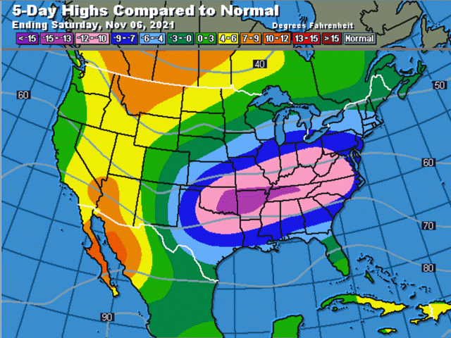
Cold Air Settling in Across Eastern US
It is starting to feel like fall. After October, which had widespread temperature departures of four to six degrees Fahrenheit above normal east of the Rockies, November has quickly reminded us which season we are in.
A strong cold front moved into the Plains and Midwest during the Halloween weekend and has continued to slip farther south early this week. The front is forecast to clear the coasts by this weekend. Morning lows in the 10s Fahrenheit have already dropped into the Northern Plains with 20s Fahrenheit across the Central Plains and Upper Midwest.
As the front continues to sag southward, sub-freezing conditions will be felt almost down to the Gulf of Mexico by week's end. This will set up the first frosts and freezes for areas that have avoided it so far from the Central and Southern Plains through much of the Delta and some of the Southeast. After such a warm October, the stark contrast may make us think that the cold is drastically early. But, in reality, it is not.
For much of Texas eastward to the Carolinas, the first frost comes either in late October or the first two weeks of November. So, the frost will be either a little late or right on time.
P[L1] D[0x0] M[300x250] OOP[F] ADUNIT[] T[]
The cold will not hang around for too long, either. A ridge of high pressure and warmer weather is set to develop across the western states during the next few days. And after a brief blip in its strength late in the week, it should move into the middle of the country during the weekend and into early next week.
Winter wheat producers are counting on this being brief. Winter wheat planting in the Plains is pretty far along and within a couple of percentage points of the average pace, but there is still 21% of the crop left to plant in Texas and 15% left to plant in Oklahoma. Kansas has nearly finished at 91% complete. Things are a bit farther behind in the Midwest, however. Illinois, Indiana, Michigan and Ohio are all behind in planting progress by more than 9 percentage points in each state and with at least 20% of the crop yet to plant. These northern states, of course, have a shorter period in which to grow good root zones and produce a couple of tillers before reaching winter dormancy.
Wet ground from a couple of storm systems that moved through in late October were the culprit for the delays in planting. With frosty conditions in the region for the next several mornings, there could be some spots with vulnerable young plants that see some damage. It will also be interesting to see if producers abandon their wheat for the year or risk it and plant late. Wheat is a hardy plant as many of us know, so a brief cool down may not have a large impact on the crop and producers may just go ahead and plant late.
While the cool down will be brief, it will not be the only one for the month. November looks more and more like a typical fall month of wildly varying temperatures up and down, and several storm systems to move through. Northern areas of the country are running out of time to have favorable weather for wheat establishment. The Southern Plains, on the other hand, typically has into December before wheat mostly shuts down.
Storm systems will be important to bring more moisture to the region that has had too little thus far this fall. In West Texas, that is especially true. Systems kept skipping over the region in October and very little precipitation was noted through the month. The front sliding south this week is going to provide at least some precipitation to the region and it will be beneficial where it falls. But more is going to be needed, especially with La Nina likely to increase drought over the winter. Wheat will need good footing in the fall to make it through early spring dryness.
The next system moves through in the middle to end of next week. Models are still very inconsistent on how to develop this system, where to place any precipitation, and how cold to make it behind it, but that will be the next chance. Those in the Plains will be asking for the rain to sustain growth; those in the Midwest would prefer to keep dry to finish up planting. With model inconsistency very high, we will just have to wait and see.
DTN Ag Meteorologist Emeritus Bryce Anderson and I will be talking about how La Nina will affect the 2022 crop season at the DTN Ag Summit taking place in Chicago Dec. 5-7. I hope you can make it out, we would love to talk with you! Visit www.dtn.com/agsummit for more details about the summit and to register. Register before Nov. 26 for the early bird rate.
John Baranick can be reached at john.baranick@dtn.com
(c) Copyright 2021 DTN, LLC. All rights reserved.


Comments
To comment, please Log In or Join our Community .