

South America Calling
La Nina for Another Season
As mentioned by DTN's Bryce Anderson in his blog on July 21, La Nina is on its way back into the Equatorial Pacific as we head into the Southern Hemisphere Spring.
You can find Bryce's blog article here: https://www.dtnpf.com/…
If you recall, last season also came in with a La Nina about the same time as this one and lasted into the Southern Hemisphere autumn before going neutral. I doubt the coming year will be an exact repeat of the 2020-21 season, but it could follow a similar pattern.
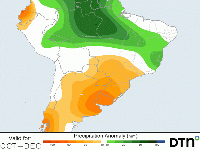
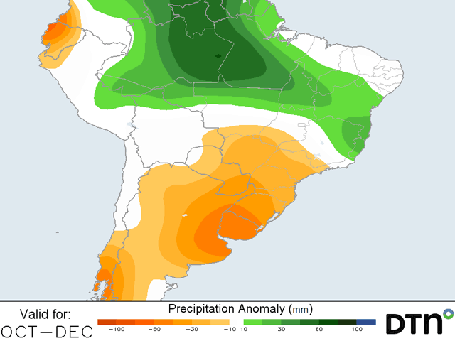
South America, and Brazil in particular, has a distinct wet and dry season. Typically, the wet season begins in mid-to-late September and lasts through late April or early May before the dry season builds back in. The climate allows for much of southern Brazil to be double-cropped, starting with soybeans in the early spring and then quickly planting corn behind it in the late summer. Under a normal year, the corn can get through pollination during the wet season before going through grain-fill in the dry season. With ample moisture from tropical rainfalls throughout the wet season, the moisture that fills the soil column usually is enough to sustain the corn crop as it fills, producing good yields when it is harvested in the winter. That is usually eight to nine months of good rainfall. In the 2020-21 season, it was nowhere near ideal.
The season started off late as the rains really did not get started until the middle of October. That set soybean planting behind schedule by about three to four weeks. There were immediate concerns that if the dry season came early, it could be a disaster for the second season (safrinha) corn crop. And that is exactly what happened.
P[L1] D[0x0] M[300x250] OOP[F] ADUNIT[] T[]
After eventual good rainfall made for a record soybean crop in Brazil and Argentina, the rains continued to cause issue with soybean harvest. That delayed corn planting another week or possibly two in some areas. Then almost immediately, the rains shut off. By mid-March, showers had become more sporadic and through April, it was clear that the rains were not coming back until the following year, except for an occasional frontal passage across the south. After corn was planted, some areas did not see another drop for close to 90 days.
A few fronts did bring showers to southern corn areas throughout the fall and winter, but the higher producing states of Mato Grosso and Goias mostly missed out on any rainfall.
And then there were frosts. As is typical during a La Nina, there is an increased risk of frosts during the winter that could have implications for immature corn. With corn running about a month behind schedule, the risks were greater.
Three rounds of frosts have already moved through southern Brazil since late June. The first hit much of the southern growing areas while corn was still in vegetative to reproductive growth stages, a critical time for frost to hit. Some private estimates along with CONAB and the USDA called for a quick 3 million-to-5 million metric ton (mmt) reduction in the corn production due to the frosts. Two additional rounds in late July hit less of the crop as more plants were reaching maturity, but anything that escaped damage on the first round were subject to colder conditions over the next two rounds that saw temperatures fall below minus 2 degrees Celsius (28 degrees Fahrenheit) in several locations.
Not only did these later two frosts affect the corn crop, but it also did some damage to wheat that was approaching or into flowering, coffee trees, sugarcane leaves, and citrus trees and fruits.
Predictions for a record corn crop in February and March were adjusted downward with every subsequent issuance. The USDA's estimate in the July World Agricultural Supply and Demand Estimates report of 93 mmt is now among the highest estimate in the world, with many private estimates falling below 90 mmt. The corn production in the 2019-20 season was a record 102.6 mmt.
Rainfall got off to a slow start as the spring months of the crop season were below normal for both Brazil and Argentina. The rainfall picked up to start calendar year 2021 and crops responded well to the timely rains. Full-season corn in Brazil and Argentina, along with soybeans, performed as expected. When the rainfall shut down quickly, it made for a disaster in double-cropped corn, which accounts for roughly 75% of the corn production in Brazil.
It would be amazing to see the 2021-2022 season follow that of the previous year, but that is the risk. La Nina usually brings a shortened wet season and increase risk of frost. Forecasters are likely going to tout these risks again as producers start to think about the beginning of soybean season next month. And again, it looks like spring 2021 will be drier than normal again. Should rains rebound like they did in the previous year, will they shut down early again?
With a sharp drop in precipitation and a distinct dry season, double-cropping corn after soybeans in Brazil is always a risky endeavor. The return of La Nina will likely spark fears for Brazilian safrinha corn producers that will risk it again. But with prices being incredibly elevated, it will be interesting to see how Brazilian farmers weigh the fears of another abysmal La Nina season with the potential profits of increased prices.
John Baranick can be reached at john.baranick@dtn.com
(c) Copyright 2021 DTN, LLC. All rights reserved.
Comments
To comment, please Log In or Join our Community .