



Ag Weather Forum
El Nino Gives a Big Boost to Southern Plains Fall Precipitation
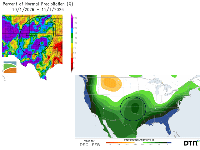
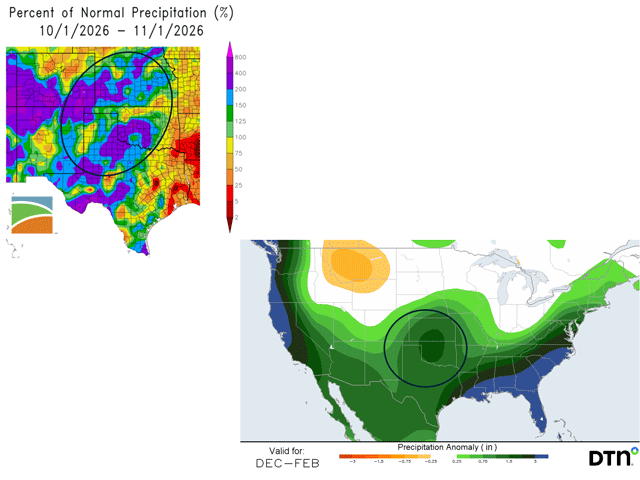
One of the hallmark features of an El Nino event in the Pacific Ocean is a strong relationship to above-normal fall and winter precipitation in the U.S. Southern Plains. We are seeing that play out in the current very strong El Nino.
The 2026-27 Water Year -- a 12-month period tracking continuous precipitation using the time frame from Oct. 1 through Sept. 30 of the following year -- is off to a heavy start in the U.S. Southern Plains. (Late September to early October is the time for many drainage areas in the U.S. to have the lowest stream flow and consistent ground water levels.) Precipitation totals that generally exceeded 2 inches -- and up to 8 plus inches in central Oklahoma -- were recorded during October. Those totals were mostly 150-400% of the normal amounts for the month.
P[L1] D[0x0] M[300x250] OOP[F] ADUNIT[] T[]
Some examples of October precipitation in the Southern Plains and relationship to normal values include: Dodge City, Kansas, 2.84 inches, 141% of normal; Wichita, Kansas, 3.50 inches, 123% of normal; Amarillo, Texas, 2.73 inches, 156% of normal; Lubbock, Texas, 3.48 inches, 227% of normal; Oklahoma City, Oklahoma, 8.77 inches, 264% of normal; Guymon, Oklahoma, 2.56 inches, 146% of normal; and Wichita Falls, Texas, 5.54 inches, 192% of normal. Further west, Alamosa, Colorado, in the Colorado Rockies recorded 3.48 inches, 535% of normal.
The impact of this substantial precipitation has been varied. In mountain areas, extremely heavy precipitation has brought devastating flooding. Meanwhile, the Southern Plains have seen some notable drought easing. Drought lessened by three to four categories in October, according to the U.S. Drought Monitor. The substantial moisture also is beneficial for the new 2026-27 Southern Plains winter wheat crop. "The October moisture provided nearly ideal planting conditions for winter wheat in Kansas," said Kansas Wheat Vice President of Research and Operations Aaron Harries in an email.
Precipitation forecasts through the end of this year and the first few months of 2027 continue with above-normal totals across the Southern Plains. For the December-January-February period (the meteorological winter season), DTN precipitation forecasts call for amounts of 1-4 inches above normal in the region, with similar above-normal totals well into the spring months. That's a promising scenario for a rebound in winter wheat production after a very dry spring in 2026 starved the Southern Plains winter wheat crop.
El Nino's influence so far in the Southern Plains also calls attention to how the U.S. winter wheat crop performed during the last two very strong El Nino events in 2016 and 2024. Both years featured a sharp increase in winter wheat production from the previous year, along with above- to much-above-normal precipitation in the Southern Plains. The precipitation totals to start the 2026-27 winter wheat cycle offer the potential for a similar story at harvest next summer. Precipitation is only one factor in winter wheat's production totals, but this start is certainly noteworthy.
Bryce Anderson can be reached at bryce.anderson@dtn.com
(c) Copyright 2026 DTN, LLC. All rights reserved.
Comments
To comment, please Log In or Join our Community .