


Ag Weather Forum
3 Hurricanes Bring Heavy Rain, Uncertainty to U.S. Weather Forecast Through Next Week
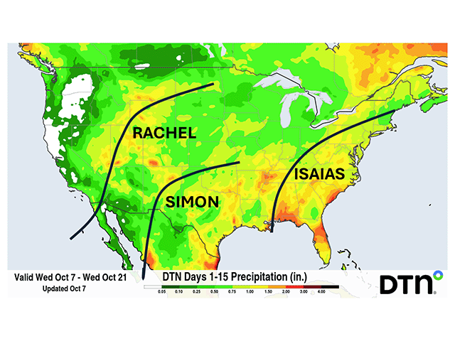
The weather pattern has certainly become a very boring and predictable one so far this week in the U.S., but Mother Nature is throwing some curveballs into the forecast via three separate current or future hurricanes that will be moving into the U.S. over the next week. Their impact will be what drives the weather forecast, but also introduces a lot of uncertainty. Small features like hurricanes have widespread impacts, but are notoriously difficult to model, especially beyond the next couple of days. Therefore, the forecast for the next week could see a lot of changes over the next several days as these features are better handled with time.
EVENTUAL HURRICANE ISAIAS DEVELOPING IN THE GULF OF AMERICA
Tropical Storm Isaias was located in the southern Gulf of America as of 10 a.m. CDT Wednesday with maximum sustained winds of 40 knots (kts), just strong enough to classify it as a tropical storm. But the incredibly warm waters of the Gulf are expected to aid in rapid strengthening of the storm into a hurricane in under 24 hours. The hurricane will move northward through the Gulf on Thursday and Friday, Oct. 8-9, likely making landfall somewhere between New Orleans, Louisiana, and Mobile, Alabama, Friday night or early Saturday morning, Oct. 10. The official forecast from the National Hurricane Center has Isaias reaching Category 2 or possibly low-end Category 3 strength before landfall.
At landfall, Isaias will bring extremely strong winds to the coast, causing widespread damage. The rapid intensification of the hurricane is likely to bring massive storm surge, especially east of the storm track from Mobile, Alabama, to Tampa, Florida. Heavy rain will hit the coast with current projections somewhere in the 5- to 10-inch range. Embedded tornadoes will be a distinct possibility as well, and travel inland with the low center on the eastern side of the track.
From there, Isaias will move northward through the southwestern quadrant of the U.S., with its remnant low-pressure center moving north of the Ohio River on Sunday, Oct. 11, before shifting into the Northeast on Monday, Oct. 12. More rain will overspread much of the country east of the Mississippi River, which could cause some areas of flooding, especially where heavy rain occurs in areas that have seen a lot of rain recently in the Midwest, Mid-Atlantic and Northeast.
P[L1] D[0x0] M[300x250] OOP[F] ADUNIT[] T[]
Though the impacts from the storm are coming into better agreement on the models, it should be noted that there remains some uncertainty in the exact track, intensity and timing of the hurricane as it moves through the Gulf over the next two days. Those in the cone of uncertainty should pay special attention to the forecast. You can stay aware of the latest from the National Hurricane Center here: https://www.nhc.noaa.gov/….
Isaias will be the first hurricane of the 2026 hurricane season in the Atlantic, the latest that the first hurricane of the season has formed in the satellite era. If records are accurate before then it would be the latest first hurricane of the season going back to 1905, which occurred on Oct. 8. Either way, this showcases the incredible effects that El Nino has had on this year's Atlantic hurricane season. Though getting to Isaias is named storm number nine, all the previous tropical storms have been weak and relatively brief outside of Tropical Storm Fay, which almost became a hurricane and waffled around in the northeastern basin for 10 days in late September.
HURRICANE RACHEL BEING ABSORBED BY WESTERN TROUGH THIS WEEKEND
Another hurricane has been moving through the Eastern Pacific Ocean for the last 12 days. Hurricane Rachel briefly made it to Category 3 strength as it moved west from the Mexican coast on Oct. 2 and is currently weakening into a tropical storm over some cooler waters on Wednesday or Thursday, Oct. 7-8. Despite its westward movement over the last week, Rachel is forecast to stop on Thursday and then take an abrupt turn northeast toward the northern Baja California Peninsula, where it may cross there Saturday night into Sunday, Oct. 10-11. From there, Rachel's remnant low-pressure center is forecast to interact with an upper-level trough that will be deepening over California. This should bring widespread tropical moisture into the Desert Southwest and Great Basin for Sunday and Monday, Oct. 11-12. Areas of heavy rain are likely to overspread southern California, Arizona, Nevada and Utah. Rainfall amounts are currently being forecast in the 1- to 3-inch range and will be enhanced by mountains spread across the area. While much of this region is in drought and will happily accept the rain, soils here cannot handle this type of rainfall without flooding consequences.
Interaction with this trough and where it may go from there are some of the uncertainties affecting the forecast for next week. Precipitation amounts not only across the Western U.S., which will see the primary impacts, but also across the northern tier of the U.S. are also uncertain. Some forecasts have the remnant low being absorbed in the western trough. However, others push the remnant low-pressure center into the Northern Plains early next week, north of a cold front that will be well to the south. With some colder air in place behind the front, there is a risk that whatever remains of the remnant low could produce accumulating snowfall somewhere in the region Sunday and Monday.
LIKELY HURRICANE SIMON MOVING NORTH INTO MEXICO, SOUTHWESTERN US EARLY NEXT WEEK WITH MUCH UNCERTAINTY
If the uncertainty with the first two hurricanes isn't enough, a third one is in the early stages of development off the southern coast of Mexico. Areas of heavy rain and an increasingly organized area of low pressure are likely to become the next hurricane in the Pacific Ocean, which would be given the name Simon. Model forecasts have this storm becoming a hurricane on Friday or Saturday, paralleling the Mexican coastline before making a move northward over the weekend and into early next week. Simon would likely cross over the southern tip of the Baja California Peninsula or pass just east over western Mexico on Monday. Like Rachel, Simon's remnants will move northward into the U.S., interacting with the western trough early-to-mid next week.
Since this hurricane has yet to form and is almost a week away from moving into the U.S., the impacts from this system are highly uncertain. However, much like Hurricane Polo last week, Simon will have the potential for spreading heavy rain into the Four Corners area and Southern Plains as the western trough makes a move eastward next week.
Unlike the Atlantic, the Pacific hurricane season has been extraordinarily busy during the building super El Nino. Simon will be the 21st named system and 11th hurricane for the 2026 hurricane season, which includes three rare storms that formed in the Central Pacific. Eight of these have become major hurricanes, making it to at least Category 3 strength. Simon will have some potential to become the ninth as waters off the coast of Mexico are extremely warm for this time of year, allowing for rapid intensification.
To stay up to date with weather conditions and your local forecast for free from DTN, head over to https://www.dtnpf.com/…
John Baranick can be reached at john.baranick@dtn.com
(c) Copyright 2026 DTN, LLC. All rights reserved.
Comments
To comment, please Log In or Join our Community .