

Ag Weather Forum
Sweeping Improvements on US Drought Monitor
It has been raining heavily across a lot of the drought areas in the U.S. this winter and an update from the U.S. Drought Monitor (USDM) on Feb. 1 gives the contiguous U.S. the lowest total coverage of drought since a four-week period from mid-May to early June 2023.
Outside of that brief break, which many farmers in the middle of the country would have disagreed with, you must go all the way back to June 16, 2020, to see lower amounts of drought for a consistent period. That was just before the Pacific Ocean entered into a La Nina state (where sea-surface temperatures near the equator run significantly cooler than normal) and sent heat and dryness into the U.S. Plains.
Since the opposite Pacific Ocean conditions -- El Nino -- cropped up in summer 2023, it has been a difficult time trying to reduce drought across the country until this winter. A southern storm track this season has brought heavy precipitation to much of the drought areas in the country, even getting into the Midwest where El Nino is less likely to produce above-normal precipitation.
Sixty-day precipitation anomalies show nearly all areas of the country from New Mexico and Colorado northeast into Minnesota and points eastward have had near- or above-normal precipitation since Dec. 1. The Pacific Northwest has also seen above-normal precipitation and an atmospheric river event moving through California over the next few days should bump seasonal totals above normal there as well. Some pockets of deficits still occurred during that time frame, including around southwestern Missouri and western Tennessee and large portions of the Northern Plains and northern Rockies, but overall, it has been a very wet winter for a lot of the country.
P[L1] D[0x0] M[300x250] OOP[F] ADUNIT[] T[]
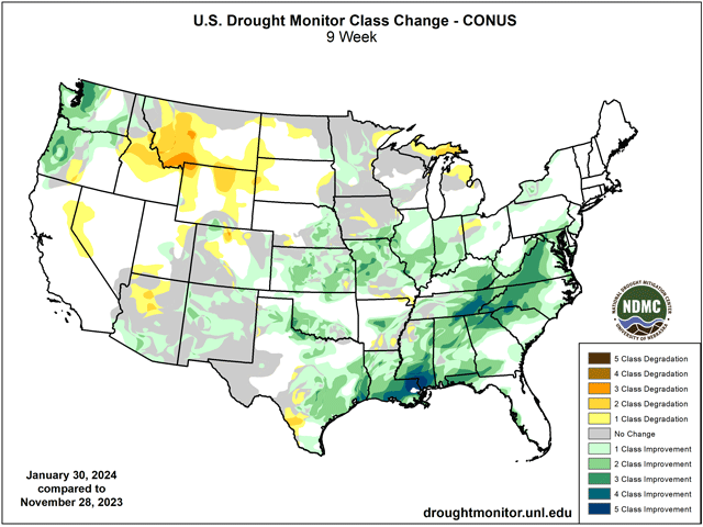
Considering the dramatic precipitation over large areas of drought, it should come as no surprise that the USDM saw massive improvements in drought this week, coming off a major precipitation event last week that produced areas of 4-6 inches and locally over 8 inches of rain across portions of the South that included a large area of D3-D4 (Extreme to Exceptional) drought in Louisiana, southeast Arkansas, northern Mississippi and western Tennessee. The streaks of red on the USDM are now very limited to small areas. That still includes parts of Iowa, Texas and New Mexico, but it is the lowest coverage of D3-D4 drought since a brief week on June 16, 2023. Again, you would have to go back to June 2020 to find this low of extreme drought coverage in the contiguous U.S.
The improvement in drought coverage has not been this significant every week since March 28, 2023, and if you include all dryness areas (D0-D4), you have to go back to Nov. 5, 2019, to see a greater improvement in U.S. drought coverage. Some small areas even saw a rare two-category improvement in eastern Texas, just south of St. Louis on the Missouri-Illinois border, and in eastern Kentucky.
Since early December, there have been large areas that have seen at least four categories of drought improvement. Those have been across southern Louisiana and Mississippi as well as eastern Tennessee, southwest North Carolina, northwest South Carolina, and northern Georgia. In fact, the area from around Biloxi, Mississippi, west to Baton Rouge, Louisiana, has gone from D4 drought down to no dryness or drought in that time frame.
And El Nino isn't done yet. An atmospheric river event is pushing through the West and particularly California this week. That will produce a storm system in the Plains and Southeast that will have more significant precipitation falling over drought areas this weekend. You can read more about that event here: https://www.dtnpf.com/….
Rain is not the only factor considered when drawing areas of drought on the USDM maps, but it is the largest. Still, there are significant long-term deficits from Kansas, through Iowa, to Wisconsin and Minnesota that are still faced with needed precipitation and boosts to soil moisture levels. Though some of these areas will see some rain on the western flank this weekend, areas around Iowa are still looking for more. The recent warmth has left many areas of the Northern Plains and Upper Midwest devoid of snow or decreasing snowpack and that could be a concern if rains are not all that heavy this spring. There is not a lot of built-up soil moisture in these areas for the start of the coming growing season. But there is a lot of time.
You can find more information about the USDM here: https://droughtmonitor.unl.edu/…
To find more weather conditions and your local forecast from DTN, head over to https://www.dtnpf.com/…
John Baranick can be reached at john.baranick@dtn.com.
(c) Copyright 2024 DTN, LLC. All rights reserved.

Comments
To comment, please Log In or Join our Community .