

Ag Weather Forum
Another Big Winter Storm Brings Polar Vortex to US This Week

Early this week, we saw the first major winter storm of the season developing in the Plains late on Jan. 7 through Jan. 8 and then cruise into the Midwest on Jan. 9. While the low-pressure center to the storm moves from the southwestern Plains through the Midwest and Great Lakes, the impacts are far-reaching with widespread heavy snow, strong winds creating blizzard conditions, heavy rain easing drought, and severe storms along the South and Southeast.
Though temperatures are falling behind the system in the Plains, the drop is toward seasonal readings for this time of year. But a storm system that develops for late week and weekend will not only have widespread impacts like the first storm, but will then be followed by a blast of arctic air from the polar vortex.
The track that the first storm is following is from the Texas Panhandle through southern Missouri and up through Michigan, a classic path for large winter storm systems. The second one in the series will follow a storm track very close to the first, but there are some differences.
The track starts out in the Texas Panhandle yet again on Thursday afternoon, Jan. 11, but instead of moving east-northeast, this one will likely take the main low-pressure center east-southeast through Texas before arcing back up into southeastern Missouri and continue into Michigan and moving through southern Ontario as the system matures.
The track is slightly off from the first and will make localized differences in the expected weather. Models are still forecasting heavy snow, but because the system is deepening over the Midwest instead of the Plains like the first storm, the snowfall amounts in the Central and Southern Plains should be less than the first storm.
A widespread area of 6-12 inches of snow fell from the Texas and Oklahoma Panhandles northeast through much of Kansas and eastern Nebraska through early Tuesday, though it has been hard to measure due to the high winds that created blizzard conditions there.
P[L1] D[0x0] M[300x250] OOP[F] ADUNIT[] T[]
The next storm has more fragmented sections of snow, with the main burst of precipitation going through Nebraska and maybe northern Kansas where another 3-6 inches is currently being forecast by models. Snowfall is much lower in other parts of the Plains going into Friday. Instead, the system bombs out in the Midwest and snowfall amounts increase into the 6- to 12-inch range and we are likely to see pockets of even more snow.
The area from Iowa and northern Missouri through Michigan is yet again in the crosshairs, though the track for the heavy snow is ever-so-slightly farther south than the early-week storm. Northwestern Indiana is being a favored location at this point by both the European ECMWF and GFS models for more than 12 inches of snow, which could include some enhancement off of Lake Michigan. The exact storm track will matter with this storm for the snow totals, but the Great Lakes areas are favored for the heaviest snows and not so much Iowa and Missouri.
To go along with the snow, very strong winds will wrap around the low-pressure center, especially in the Midwest. Exact wind speeds and gusts are still a bit questionable, but there is potential for sustained winds over 35 mph and gusts over 50 mph in a lot of the Midwest, which would produce blizzard conditions and lots of blowing and drifting snow.
Where it is still warm enough for rain, it will be heavy yet again. The Ohio Valley south to the Gulf of Mexico and through the East Coast saw heavy rain with the early-week storm. Rainfall amounts over 2 inches were common in a lot of areas, especially those areas in the South and Southeast that saw significant thunderstorms. With the coming storm, models are more fragmented with the showers and thunderstorms farther south, as the fetch of moisture from the Gulf of Mexico will not be as great as it was for the first storm. However, those in the Ohio Valley will be favored with amounts approaching 2 inches this go-around.
Severe weather occurred early this week and another round in similar fashion is forecast for the late-week storm. The same areas from east Texas through Georgia and the Carolinas are being pegged by the Storm Prediction Center as having an elevated risk of severe weather. Strong winds and tornadoes will again be the primary threat.
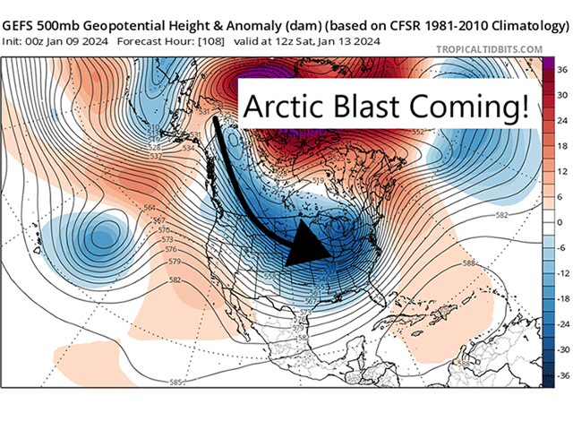
But even bigger than a second monster winter storm is what happens after the storm passes by. The polar vortex has been building in Western Canada early this week and is starting to pull down some cold air from the Arctic. Through Wednesday, that will continue to build in Canada. But the late-week system will pull down the harsh arctic air into the Northern Plains starting Jan. 11 and continue to pull it through most of the country behind the storm through the weekend. Temperatures are forecast to go below zero Fahrenheit as far south as Kansas and as far east as Illinois by Jan. 14, which continues across much of the Plains and Midwest through the middle of next week. There may be a few days where temperatures do not make it into positive territory this weekend across the Northern Plains and Upper Midwest. Certainly the Canadian Prairies will struggle below zero F for a several-day period.
Models disagree on the potential for moderation, with some models suggesting a brief burst of warmth around the middle of next week, followed by another shot of arctic blast for late week and weekend before moderating the following week (after Jan. 21).
Others do not have the midweek moderation, but start the trend earlier late next week or weekend instead of the following week. Either way, a good period of cold air will beset the Canadian Prairies and middle of the U.S. for mid-January. And those with fresh snow cover, which will be a lot of the country by the end of next week, will be slower to moderate.
That cold air will likely set up a third storm system with a farther south storm track for Jan. 14-16. Models are still working this out, but would probably take a track from Texas through the Gulf Coast and up into the Mid-Atlantic.
With the cold air in place in these areas already, that could turn into a wintry mess for southern areas of the country. Texas and Oklahoma east through the Tennessee Valley and Carolinas are being watched for potential snow and ice storm if this all comes together, which is somewhat questionable.
To find more weather conditions and your local forecast from DTN, head over to https://www.dtnpf.com/…
John Baranick can be reached at john.baranick@dtn.com
(c) Copyright 2024 DTN, LLC. All rights reserved.
Comments
To comment, please Log In or Join our Community .