Ag Weather Forum
Unfavorable Ocean Combination Including Strong El Nino Dries Out Australia's Wheat Moisture Forecast
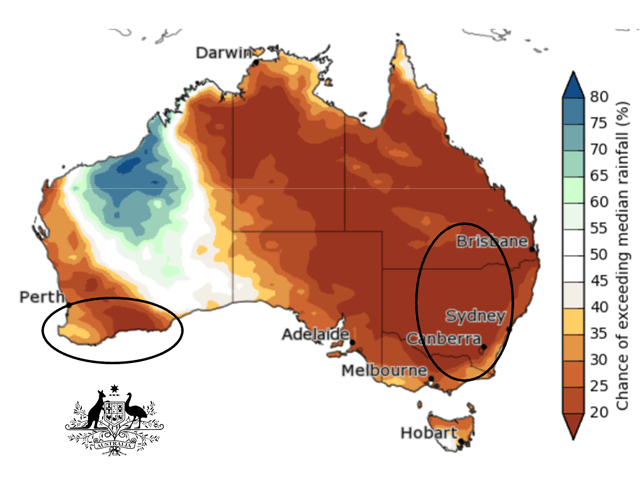
After a run of bountiful harvests, Australia's 2023-24 wheat crop is indicated to go into the grain production and filling stages with much less soil moisture than in recent years.
USDA noted in the September 2023 World Agricultural Supply and Demand Estimates (WASDE) report that "Australia (wheat production estimate) is reduced 3 million tons to 26 million as dry weather this past month in Western Australia, New South Wales, and Queensland lowers yield prospects." That change is not minor; it is more than a 10% decline in estimated Australia wheat crop size in just one month.
El Nino conditions in the Pacific Ocean are responsible for a good portion of the drier trend. (The term El Nino notes the development of large-scale sea surface temperature, or SST, warming to above normal in the equatorial region of the Pacific.) The Australia Bureau of Meteorology (BOM) noted in its latest tropical weather and climate commentary that large-scale atmospheric circulation and above-normal sea surface temperatures have now synchronized in the Pacific Ocean.
P[L1] D[0x0] M[300x250] OOP[F] ADUNIT[] T[]
"Overall, there are signs that the atmosphere is responding to the pattern of SSTs in the tropical Pacific and coupling of the ocean and atmosphere has started to occur," the BOM report said. "This coupling is a characteristic of an El Nino event and is what strengthens and sustains an event for an extended period. Climate models indicate this El Nino is likely to persist until at least the end of February. El Nino typically leads to reduced spring and early summer rainfall for eastern Australia, and warmer days for the southern two-thirds of the country."
However, El Nino is not the only big ocean feature leading to a drier outlook for Australia's wheat regions. In the Indian Ocean, a sea surface temperature and air pressure feature known as the Indian Ocean Dipole (IOD) is also in a phase that brings drier conditions to Australia. The IOD compares conditions between the western portion of the Indian Ocean (Arabian Sea toward Africa) and the eastern portion (Western Australia, Indonesia, Malaysia, New Guinea Southeast Asia). And, currently, the IOD is in a positive phase, with the western sector above normal in temperature while the eastern sector is below normal in temperature. As with El Nino, the warmer western sector is in line for more convection with rising air and heavier rain, while the cooler eastern sector has reduced convection, more of a sinking pattern in the atmosphere, and lighter rain forecast.
The Indian Ocean Dipole (IOD) index is plus 1.25 degrees Celsius for the week ending Sept. 17, the Australia BOM commentary noted. "This is its fifth week above the positive IOD threshold (plus 0.40 degrees C). The longevity of this trend, combined with the strength of the dipole being observed and forecast, indicates a positive IOD event is underway. All models predict this positive IOD will persist to at least the end of (Southern Hemisphere) spring ..."
The summation of the BOM comment is important: "When a positive IOD and El Nino occur together, their drying effect is typically stronger and more widespread across Australia."
With this ocean combination bringing a drier trend to Australia's wheat regions, the prospect of further declines in production estimates is not out of the question.
The full Australia BOM commentary is available here: Tropical Climate Update (http://www.bom.gov.au/…)
Bryce Anderson can be reached at Bryce.Anderson@dtn.com
Follow him on X, formerly known as Twitter, @BAndersonDTN
(c) Copyright 2023 DTN, LLC. All rights reserved.


Comments
To comment, please Log In or Join our Community .