

Ag Weather Forum
Models Ease Cold, Increase Precipitation This Week

Last week, models were insistent that a round of cold air would flood the country east of the Rockies, pushing the storm track to the south. Since Friday, those models have been steadily easing up the gas on the cold outlook for a lot of the country, while simultaneously keeping the active weather track right through the U.S. The increase in precipitation continues the overall wet pattern across a good majority of the country here for another week.
A large trough out in the western half of North America is being contained for the time-being by ridges in Alaska, Greenland, and the Southeast. However, that trough is still strong enough to send a few pieces of energy through the U.S. over the next several days. That has already led to some moderate to heavy snow yet again from Montana to Michigan since Sunday, similar to a storm track last week. That individual storm continues eastward Monday, moving off the Mid-Atlantic coast on Tuesday. Some small disturbance will move out into the Plains for Tuesday and Wednesday, where additional showers are expected to develop, again with some moderate snow across the north.
P[L1] D[0x0] M[300x250] OOP[F] ADUNIT[] T[]
The Southeastern ridge will finally give out later this week and allow a large chunk of the western trough to shift east. That should induce yet another strong storm system that moves through most of the country. With the ridge out of the way, the cold front is likely to go sweeping deeper south and bring some more moderate temperatures with it. However, the system will also be ingesting some increasingly pacific air, moderating that drop in temperatures. Unfortunately for those in the West, Northern Plains, and Canadian Prairies, that moderation does not come until late in the week, and significantly colder temperatures will remain in place for the next few days. However, average temperatures continue to rise and well-below normal does not have the same bite to it here in March as it would have in January.
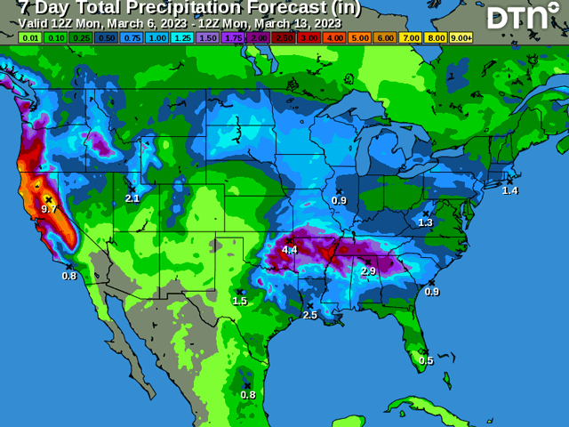
Back to the precipitation, it will be intense for many areas of the U.S., notably across the North-Central, Southeast, and areas in-between. The West will also see nearly continuous precipitation this week. With cold-enough temperatures across the north, that is likely to mean significant heavy snow, especially with the late-week system. Snowfall amounts are still being worked out by models, but significant amounts over a foot are possible over a wide area from Montana and Wyoming to Michigan yet again. That is still to be determined, however, so expect changes to your local forecast over the coming days. We could see some severe reports out of thunderstorms across the southern half of the country as well.
One more storm system will move off the western trough Friday, moving through the middle of the country this weekend and off to the east Monday as the parade of storms continues. What was looking like a quieter week ahead is now a continued active one. Precipitation over the winter has led to widespread drought reduction for large sections of the country. The southwestern Plains have not been as lucky. Systems have routinely passed this area by, only bringing lighter amounts at times. Some streaky thunderstorms brought some better rainfall to select locations last week, but this week looks dry yet again. With wheat and forages waking from dormancy, they continue to find poor conditions. Buried in sand and dust with little or no soil moisture, the outlook continues to be unfavorable, even in the active pattern.
To find updated radar and analysis from DTN, head over to https://www.dtnpf.com/…
John Baranick can be reached at john.baranick@dtn.co
(c) Copyright 2023 DTN, LLC. All rights reserved.
Comments
To comment, please Log In or Join our Community .