

Ag Weather Forum
Killing Frosts May Be On The Way
It appears many states still have plenty of corn and soybeans yet to reach maturity, according to the latest USDA NASS Crop Progress Report. Most states are behind last year's rapid pace, a year which saw some earlier planting. The picture is a little more mixed when it comes to the five-year average. Some states are ahead while others are behind, making it pretty close on the national scale. But the states that are behind in both last year and the five-year average are all in the Corn Belt. Due to late planting across many areas, more of the crop, or at least a good chunk of the totals, is still susceptible to frost and freeze damage. As of Sunday, corn maturity on the national scale was at 75% while soybeans dropping leaves were at 81%. That leaves about 20% to 25% of the crop still vulnerable to frosts to some degree. In states like Ohio and Pennsylvania, that total could be as high as 40%.
You can read more about the potential damage from frost by DTN Crops Editor Jason Jenkins here: https://www.dtnpf.com/….
In that piece, I told Jason models were hinting at a cold shot for late this week. But at the time, they appeared to favor a glancing blow. Over this past weekend, those models turned to a much stronger and widespread risk for cold air settling over the eastern two-thirds of the country. On its own, the air is not extremely cold for this time of year, maybe five- to ten-degrees below normal. However, the air will receive a boost to the low side where winds calm down, skies clear out, and soils are rather dry. Those three factors could make for some more-significant cold morning temperatures and cause temperature patterns to vary widely over short distances.
P[L1] D[0x0] M[300x250] OOP[F] ADUNIT[] T[]
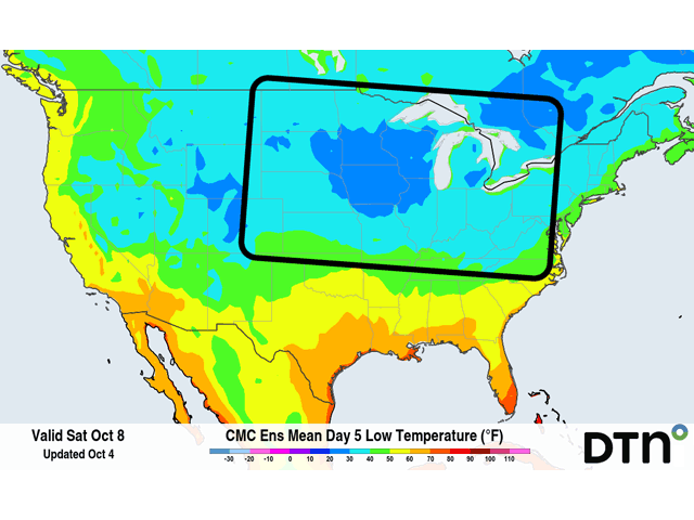
For the Western Corn Belt -- west of the Mississippi River -- temperatures are likely to reach below 32 degrees the mornings of Oct. 7-8. But North Dakota and northwest Minnesota could also see some frosts on the morning of Oct. 6. East of the Mississippi, those are more likely on the mornings of Oct. 8-9.
How far south the frost line might get is still in question and depends just how calm the winds get and how clear the skies remain. Behind the cold front, winds out of the northeast will rise into the Rocky Mountains and produce clouds and potential for showers in the southwestern Plains. There is some potential for frosts to occur in southeast Colorado or southern Kansas, but that risk is probably low. Much of the corn crop is already mature in these states anyway and limited impacts would be expected from frosts or freezes. Soybeans, on the other hand, are more vulnerable. For the Eastern Corn Belt, clouds are likely to be less of a factor. Soils that are a little more moist could keep temperatures up in some areas, and there may be some lingering clouds in some areas. But the risk for frosts extends south through Kentucky and possibly areas of Tennessee as well. Again, soybeans are more at risk than corn in these areas.
Frosts in the southern Corn Belt are coming about two weeks earlier than normal. That seems unusual when the forecast for the month continues to be above-normal temperature-wise. But this is how Mother Nature likes to change seasons -- in steps. Average temperatures fall through the autumn season, and we are all aware of that. But the way She likes to do it is in steps. A strong cold front will move through to knock down temperatures, then a few days of recovery will happen before another knockdown in temperatures occurs. Of course, it is not always as simple as that, but that is the general idea. That means these knockdowns may not be strong enough or long enough to outweigh the recovery periods and, thus, above-normal temperatures exist for the month.
Either way, the frosts are coming and another step downward is expected next week as well. Models again are bringing a strong cold front through the country around the middle or end of next week. If areas escape the killing frosts this week and weekend, they will be at risk again next week. And only time will tell how vulnerable crop yields really are to these killing frosts.
To find more regional weather conditions and your local forecast from DTN, head over to https://www.dtnpf.com/…
John Baranick can be reached at john.baranick@dtn.co
(c) Copyright 2022 DTN, LLC. All rights reserved.

Comments
To comment, please Log In or Join our Community .