

Ag Weather Forum
Waning La Nina Brings Challenges for Spring Planting

Note: This is an update to the spring planting season forecast across the U.S. I laid out some of the highlights in a previous article here: https://www.dtnpf.com/….
La Nina is loosening its grip on the Pacific Ocean, but it is going to take quite a while for it to go away completely. Forecasts are expecting the feature to continue having an influence on weather across North America going into May.
If the American climate model has any say, La Nina conditions could stick around all the way through summer. That is an outlier, though. Almost all other major climate models from around the globe have ocean temperatures hovering around normal by the summer. The ones that do not follow suit to a neutral state are among the least-accurate models that are available. Following the consensus, and not the American model, is the basis for this forecast.
But before we talk about what conditions we are going to see, it is a good idea to remind everyone where we sit on the first day of meteorological spring, March 1.
Drought is and will continue to be the story heading into the 2022 growing season. La Nina has had its influence in increasing drought across much of the West and Central and Southern Plains. The Southern Plains has especially been building drought as the main storm track has either passed off to the north, or the systems that have moved through have skipped over the traditional hard red winter wheat areas. Drought there is very concerning for winter wheat in the short term, and corn, soybeans, and pasture in the long term.
Since Jan. 1, North America has been in a typical La Nina pattern that produces a ridge of high pressure across the Eastern Pacific up into Alaska. With a trough being favored over Hudson Bay, the resulting storm track has favored frequent clipper systems moving over the top of the ridge, sliding down across the Canadian Prairies, and through the Great Lakes.
This has allowed some beneficial precipitation across drought areas in the Canadian Prairies and Western Corn Belt, but not everywhere. Clippers are notorious for light precipitation events. Those can combine to produce moderate to heavy precipitation where they are more frequent, and leave areas dry with growing drought where they miss more often.
P[L1] D[0x0] M[300x250] OOP[F] ADUNIT[] T[]
Drought has been reduced across a good portion of the Canadian Prairies and far northern Plains, but increased across South Dakota, Iowa, Wisconsin and Michigan since Jan. 1.
Those clippers have been able to pick up better moisture when they get to the Great Lakes, bringing better precipitation to the Eastern Corn Belt, Midsouth and into the Northeast. That has certainly been the case during February as flooding has been more of a concern that drought.
And that has been the overall theme since the start of the 2021 season. Drier conditions building in the West and wetter conditions in the East with a mix in between. March is starting to be a little anomalous in that regard. The DTN forecast and the overall pattern favors a larger trough in the West and a ridge in the Southeast for much of the month and especially the first half. The storm track will fall between the two features, causing systems to dig into the West, emerge into the Plains, and pick up moisture from the Gulf of Mexico on their way east of the Mississippi River.
Overall, that is a favorable track for widespread precipitation events across much of the country's growing regions. Drought areas in the Pacific Northwest and across the Central and Northern Plains through the Upper Midwest stand a good chance at reduction.
Meanwhile, wet areas east of the Mississippi River continue to be favored for saturated soils and building subsoil moisture for the month. But unless those storms track down into Texas, the prospect for getting good precipitation to the southwestern Plains is middling. This area of the country, which continues to be deep in drought, will need the precipitation to overachieve in March because the forecast for April and May is not favorable for increased precipitation.
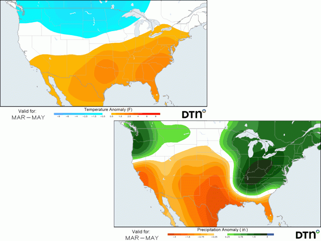
While March is a break from La Nina dominance, April is trending to look a lot like that clipper pattern from the winter. Conditions are likely to result in near- to below-normal temperatures across the north while warmer and drier across the south. In terms of precipitation, the clippers will cause mixed precipitation across the Canadian Prairies and Northern Plains, but increased precipitation again east of the Mississippi River, especially in the Ohio Valley. The cooler conditions across the north will lead to some risks of late frosts. We may see that linger into early May as well.
But the rest of May is forecast to be mostly above normal in terms of temperatures. For precipitation, the only area forecast to see the above-normal precipitation continues to favor the Eastern Corn Belt. Drier conditions elsewhere could impact planting and early growth.
So to recap:
-- Colder, wetter conditions in the eastern Midwest will likely lead to shorter planting windows, keeping the stress up for producers. The risk for late frosts could cause some replanting if the frosts do occur. However, soil moisture should be favorable for early growth.
-- In the Northern Plains into the Upper Midwest, wetness in March will be key to getting these areas out of drought prior to spring planting. Planting windows may be a little longer, but the impact of drought is likely to weigh on early growth at least in some areas.
-- In the Central and Southern Plains, areas that do not see drought reduction in March are likely to suffer increasing drought through the spring. Planting will be easy, but early growth is likely to be limited.
-- Down in the Delta and through the Southeast, conditions are likely to be much better than the rest of the country. A wetter March will likely reduce drought across the south, and drier, but not completely dry conditions in April and May should lead to better planting windows. Southern areas could still see adverse conditions, however.
-- And out in the Pacific Northwest, drought will continue to be an issue. March is going to try and help alleviate some of the poorest of conditions and could set up the region with good irrigation from mountain runoff. But drier conditions in April and May could turn the tide back toward drought building. Spring wheat planting may go off without much concern, but early growth could be affected.
To find more regional weather conditions and your local forecast from DTN, head over to https://www.dtnpf.com/…
John Baranick can be reached at john.baranick@dtn.com
(c) Copyright 2022 DTN, LLC. All rights reserved.
Comments
To comment, please Log In or Join our Community .