

South America Calling
South America Precipitation Disappointing in November
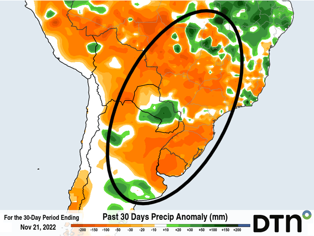
It has been dry in South America during the last month, especially in the last three weeks. The first two-thirds of November have produced below-normal precipitation for almost the entire continent's primary growing regions.
Drought has been well-advertised in Argentina since last year. But a good start to the growing season in Brazil has flamed out a bit in November. According to analysis by DTN, the last 30 days, which includes the end of October as well, have seen readings roughly 30 to 75 millimeters (1.2 to 3 inches) below normal for most of Argentina and Brazil. That is roughly 30-60% of normal rainfall.
Recent rainfall has improved over northeastern Brazil. Paraguay has seen near- or above-normal precipitation. Localized heavy rain also occurred over far southern Argentina's growing areas. But the primary areas in Argentina, and southern and central Brazil, have all seen levels below normal. With temperatures regularly in the 30s Celsius (upper 80s to near 100 Fahrenheit) outside of frontal passages, soil moisture has been falling for a lot of areas during this month.
P[L1] D[0x0] M[300x250] OOP[F] ADUNIT[] T[]
Rainfall at least has been somewhat frequent, raining in most places at least once a week. Even though rainfall has been largely disappointing, it has yet to affect crop ratings in the state of Parana, where rainfall has been roughly 60-80% of normal this month. According to the local government, good-to-excellent ratings for corn are at 85% while soybeans are at 93%.
Rains have been more irregular in central Brazil, with the wet season disappointing so far despite starting on time. Some pockets in Mato Grosso have reportedly not had rain this month. There is some concern that the dryness of late could drop yields. However, the critical time period for soybeans to get rain is in December and models are picking up rainfall in this area of the country next week especially.
In Argentina, recent rains have been trying to make up deficits, but have not been able to do so just yet. Once-per-week fronts moving through with a day or two of rains has not been able to make up for the deficits for the most part. The dryness that usually follows saps any benefit of the recent rains. Crop ratings have stabilized, but are still poor. According to the Buenos Aires Grain Exchange, good-to-excellent ratings for corn are just 11%, an increase of just 2% from the previous week, while poor-to-very poor ratings are at 28%, a decrease of 6% from the previous week. Wheat ratings remained dismal with 56% poor-to-very poor. Improvements have not been widespread and the rains are likely too late for wheat as more of that crop heads toward maturity and harvest picks up.
La Nina has been showing its strength here during November. Long-range models continue to show concern for below-normal rainfall in December for southern Brazil and Argentina with more disappointing rains when they do come. Trends like this are having a negative impact on corn in Argentina and will start to affect soybean production during the coming weeks as well.
For a more extended look at South American weather, join me at the 2022 DTN Virtual Ag Summit Dec. 12-13. Get all the information you expect from DTN, from the comfort of your home or office. For details on the agenda and how to register, visit www.dtn.com/agsummit
John Baranick can be reached at john.baranick@dtn.com
(c) Copyright 2022 DTN, LLC. All rights reserved.

Comments
To comment, please Log In or Join our Community .