

South America Calling
Concerns Loom for Safrinha Corn Production in Brazil After Good Start

The second-season (safrinha) is well underway. The corn crop was planted mostly in the preferred window. The Mato Grosso Institute of Agricultural Economics (IMEA) estimates 93% of the crop was planted before the start of March. With that favorable planting start, part of the crop is approaching pollination stage. As per usual, southern Brazil is a little later with their planting, but Parana was planted before the start of April, which is ahead of last year's pace by about two weeks in many instances.
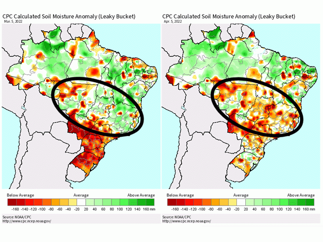
Soil moisture in central Brazil early in the season had been very good. Heavy rainfall over the first-crop soybean season was exceptional, filling soil columns and setting up safrinha corn plants with uniform germination and early growth. Farther south in Parana and Mato Grosso do Sul, drought in the first-crop soybean season weighed heavy on the prospects for the safrinha corn crop. But rainfall over the last month has been exceptional for most of the region. Estimates totaling 150 to 300 millimeters (mm) (about 6 to 12 inches), which is some 25 to 100 mm (about 1 to 4 inches) above normal and more in some cases, has led to vastly improved soil moisture.
The improvement across the south and good early conditions farther north have led to increased production estimates from private firms. CONAB increased its total corn production estimate to 115.6 million metric tons (mmt) on April 7. That is up from 112.3 mmt in its last report in March.
P[L1] D[0x0] M[300x250] OOP[F] ADUNIT[] T[]
However, rainfall over the last couple of weeks in central production areas, which account for 60% to 70% of safrinha corn production in Brazil, have seen showers waning ahead of the start of the dry season. Some production areas in western Minas Gerais have seen total rainfall below 25 mm (about 1 inch) over the last month. Farther west, those amounts have been higher. Mato Grosso has picked up an estimated 75 to 150 mm (about 3 to 6 inches), but those heavier amounts are spotty around the state and even these higher amounts are below normal.
Subsequently, satellite estimates of available soil moisture have been on the decline from Mato Grosso to Minas Gerais in recent weeks. And the forecast for this part of the country over the next week is dismal. Some isolated showers may dot the landscape at times, but anything of consequence is looking rather unlikely. Instead, southern Brazil and Paraguay are forecast to see daily showers in the region. Conditions over the next week will only worsen in central Brazil but should continue to look good in southern Brazil.
Typically, the end of the wet season comes in the first couple of days of May to central Brazil. With La Nina's influence, that usually quickens the end time by a week. Indeed, longer-range models are indicating the potential for that dryness to begin in late April as opposed to May, but the region is running out of time regardless.
There is some hope though. A front moving across Argentina over the weekend will concentrate showers in southern Brazil and Paraguay early next week. The front and subsequent shower activity will move northward into central Brazil around the middle or end of next week. However, shower potential will be limited from that diffuse front, even with it stalling in the area going into the following week. Models previously indicated better chances for rainfall across central states in the middle of the April before starting the dry season. However, recent runs have been forecasting more limited shower potential in the core production states.
There is little doubt plants in the field look fantastic right now, and it should not be a surprise that both public and private estimates for corn production have increased. However, the soil moisture situation in central states and the limited rainfall forecast for the rest of the month should give us pause in thinking that the crop is headed toward a great season. If showers in the middle of the month do not end up increasing soil moisture, we could see corn suffering as it still has more than two months to go before harvest picks up.
Southern states are in better shape, but only account for about 30% of total safrinha corn production in the country. A better crop in this area of the country may not be able to make up for the potentially lower production farther north. Those showers in the middle of the month will be key to further production estimates. And, of course, frost issues may creep into southern states especially. If it occurs before the end of June, we would likely see production issues across the south add to those potentially in the north.
To find more international weather conditions and your local forecast from DTN, head over to https://www.dtnpf.com/…
John Baranick can be reached at john.baranick@dtn.com
(c) Copyright 2022 DTN, LLC. All rights reserved.
Comments
To comment, please Log In or Join our Community .