

South America Calling
Favorable Growing Conditions, For Now
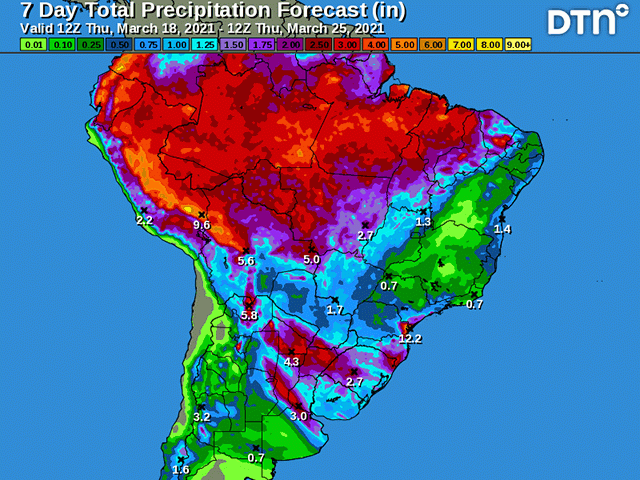
Rainfall during the past week has been quite significant for Argentina and southern Brazil. Rainfall amounts have been in the 1- to 2-inch range for the most part with some locally heavier amounts as well.
This will lead to widespread improvements in topsoil moisture for corn and soybeans that are still going through reproduction and filling. There is some of the crop going through maturity, however, and the rainfall is not having a tremendous positive impact for these. But this represents a small portion of the crops so far.
This is just the first in a line of several storm systems that are lining up for the continent through the end of March, which could ease a lot of concerns for corn and soybean producers in these regions.
P[L1] D[0x0] M[300x250] OOP[F] ADUNIT[] T[]
Farther north in central Brazil, showers continued to provide adequate to surplus moisture from Mato Grosso to Minas Gerais last week as daily showers dotted the region.
There will be a change to this come next week. While the activity switches more to Argentina into southern Brazil, central areas are likely to dry out. Showers may continue over western Mato Grosso, but most of the main growing regions in the middle of the country will go dry next week.
This starts a drier trend in this region that may have lasting impacts for the rest of the season. Models indicate that this region will see below to well-below-normal precipitation through at least the middle of April.
Recent showers have been able to increase soil moisture for these areas rather significantly, producing some adverse wetness, but also filling soil profiles through the entire column for much of the region.
This will be important as safrinha (Second-crop) corn continues to develop. Dryness during this time of year isn't entirely detrimental, as it should force corn to develop deeper root systems, but it will deplete some of the reserves that have been built up over the last two months.
Should the rains still continue to come in below normal through the end of April and into May, which is the usual start of the dry season in the country, corn will likely run out of moisture during reproduction or early fill. Models and the DTN forecast point toward rainfall returning to normal during this critical time, but absolute amounts are also undergoing a steep downturn at this time.
Rainfall of around 15-20 millimeters, or roughly 0.50 to 0.75 inches, is typical for the last week of April. For corn enduring temperatures in the middle 30s Celsius (upper 80s to lower 90s Fahrenheit), a half inch of rain will not be sufficient during the most critical time of development, forcing the plants to extract more subsoil moisture. If it is not there due to a dry period through the middle of April, there could be some significant reductions in yield. Even normal rainfall would not be able to keep up with demand should the subsoil moisture dry up.
John Baranick can be reached at john.baranick@dtn.com
(c) Copyright 2021 DTN, LLC. All rights reserved.

Comments
To comment, please Log In or Join our Community .