
Ag Weather Forum
Fall Harvest Forecast for US

Harvest season is upon us and the relatively dry conditions for most of the country over the last several weeks have given rise to early dry-down and allowed equipment to get out into the fields. According to the NASS Crop Progress report, as of Sunday, Sept. 9, the corn harvest is 5% complete with 34% mature, 1% and 6% ahead of the five-year average, respectively. For soybeans, the harvest numbers aren't in yet, but 31% are dropping leaves, ahead of the five-year average of 25%. Southern states that plant earlier lead the way, but the weather from here on out will play more of a role in harvest than in crop production, outside of an early frost, even for northern areas or an extreme weather event.
Thus, our attention turns to harvest and how the weather may impact conditions as equipment goes back into the fields. So far, as mentioned, most areas are relatively or extremely dry from the dearth of rainfall over the last few weeks. There are notable exceptions like Michigan and Ohio, which saw some heavier rain in late August, and in spots of the Central and Southern Plains where moderate-to-heavy rain has fallen this week and is forecast to continue for the next few days. However, a vast majority of the country should be ready to roll.
P[L1] D[0x0] M[300x250] OOP[F] ADUNIT[] T[]
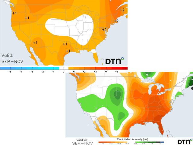
Conditions for the rest of September should be largely benign, as well. The weather pattern is a bit progressive this week and next. That would usually suggest several systems moving through, which should be true. But models do not foresee a lot of rainfall coming out of these systems, except in the Central and Southern Plains as I noted above. A system that moves into the Northern Plains later next week looks promising for producing areas of rain there, but models dry out that system as it quickly races into Canada, even though the front may get left behind across the Corn Belt. I will reserve judgement for that part of the forecast, but overall, there does not seem to be a lot of precipitation in the forecast for much of the country for the rest of the month. A tropical storm could ruin that forecast though and, yes, we will be watching both Hurricane Lee, which is expected to only impact the Northeast this weekend, and another storm currently out in the middle of the tropical Atlantic that may make a pass near the U.S. mainland late next week or weekend; but right now, there are no imminent threats.
As we move into October, models are suggesting a more variable weather pattern, including more of an eastern trough. Such a feature would mean cooler temperatures for parts of the Plains and Upper Midwest and periods of precipitation throughout areas east of the Rockies, though nothing that would suggest big storm systems. For those harvesting during the month, the weather again looks rather benign, though there could be some occasional short-lived delays as systems pass through. And the tropics will need to be watched as well with extremely warm sea-surface temperatures out there.
Once we get later into November, though, the pattern starts to take on an El Nino shape. That encourages storm systems across the southern tier of the U.S. and warmth farther north. Early in the month, we may be stuck in a hangover from October, leading to cooler conditions underneath the trough and some occasional precipitation. If the two line up, it could mean some early snow across the northern tier of the country, but that is just speculation. More likely though, it will become easier to harvest later in the month across northern areas as the jet stream splits and brings warmth. Any folks across the south with harvest or other fieldwork yet to complete may find more challenging conditions if the forecast pans out.
Overall though, harvest weather is in fairly good shape, especially for the majority of the country. Soft soils in limited areas now will largely dry out this month. The main concern then is soil recharge going into the winter season. Outside of the South and Southeast, which may include portions of the Central Plains as well, soil recharge over the drought is more of a regional proposition based on where storms eventually track.
To find more weather conditions and your local forecast from DTN, head over to https://www.dtnpf.com/…
John Baranick can be reached at john.baranick@dtn.com
(c) Copyright 2023 DTN, LLC. All rights reserved.
Comments
To comment, please Log In or Join our Community .