

Ag Weather Forum
Another Week, Another Big Spring Storm
The spring season has certainly been an active season thus far. Severe storms are picking up, exemplified by the tragic tornado that plowed through Mississippi March 24 that killed at least 26 people.
Snow continues to fall, sometimes in heavy bands. One occurred with that same system across eastern Iowa through eastern Wisconsin that dropped over a foot in some locations March 24-25. And winds continue to be strong as these large systems go by.
That is especially true in the Plains where we have seen multiple instances of storms bringing wind gusts over 60 mph. True to the pattern, another storm system will create all three hazards later this week.
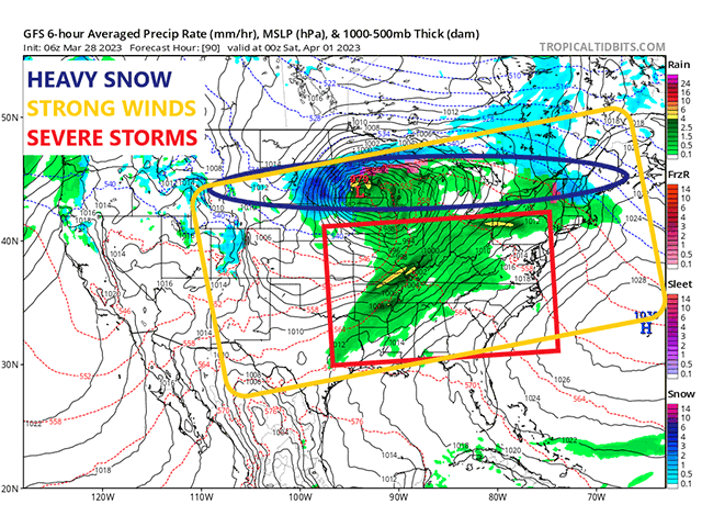
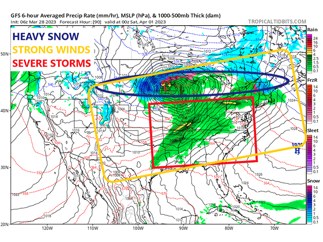
The storm is currently entering the West Coast as of March 28, bringing more heavy precipitation to northern California, southwest Oregon and much of the western states during the next couple of days. That system will emerge into the Plains March 30 and will quickly ramp up the wind gusts for much of the region. From Nebraska south through Texas, wind gusts of 40-50 mph will be rather common, with some areas achieving higher gusts.
P[L1] D[0x0] M[300x250] OOP[F] ADUNIT[] T[]
That goes for the southwestern quarter of the region that is likely to see gusts exceeding 60 mph at times. Winds that strong are only worsening the impact of the drought on the region, sapping any sort of soil moisture that the area still clings to, but also producing blowing dust and sand that buries cropland in drifts of dry material that is hard for anything to grow out of. The stronger winds may follow the storm farther east for Friday and Saturday as the calendar shifts to April.
As the system exits into the Plains, the strong winds will increase moisture across the Plains and Mississippi Valley, allowing for areas of showers and thunderstorms to develop. Unfortunately for those drought areas in the southwestern Plains, they will be bypassed by this system, as they have been with most of the systems in the last several months. You can read more about the situation in the southwestern Plains from DTN's Bryce Anderson here: https://www.dtnpf.com/….
We should see a burst of precipitation moving through the Midwest to start on Thursday and Friday, but the storm should increase its presence over the Plains for Friday and then into the Midwest with another burst on Friday and then into Saturday as the system moves to the East Coast. Widespread precipitation is forecast from the system. The bursts should be moving fast enough that flooding will not be a large concern. However, the upper-level dynamics should make for a significant severe weather threat for Friday in the Mississippi Valley and by extension into the Ohio and Tennessee Valleys. That threat may move to the East Coast for Saturday. The exact threats and locations are still being determined, but all modes of severe weather do look likely for a wide area of the country from this storm.
And yet another band of moderate to heavy snow is forecast out of this system. This time, the likelihood is from South Dakota through Michigan and possibly into the Northeast as well. Heavy snowpack already exists in part of this track, and some areas that have seen some melting will see additional snow pile up.
The heavy snowpack extends north into the Canadian Prairies as well. The flood threat this year is high due to the high amounts of water contained within this snow. That could spell trouble later in April as temperatures increase. The cold will last through this storm and into next week, though, so melting will be limited. But if temperatures turn sharply later in April, it could spell a quick melt of a lot of water. I wrote about that last week here: https://www.dtnpf.com/….
This system will be just another in the long line of strong storms that have moved through the country over the last few months. And it will not be the last. Models are also focused on another strong storm potential in the April 3-6 timeframe. For those wanting to get out to work on your yards or fields, it continues to be a difficult task to accomplish with Mother Nature throwing her best at the country.
To find updated radar and analysis from DTN, head over to https://www.dtnpf.com/….
John Baranick can be reached at john.baranick@dtn.com
(c) Copyright 2023 DTN, LLC. All rights reserved.
Comments
To comment, please Log In or Join our Community .