
Ag Weather Forum
Areas of Frost Moving Into Southern US This Week
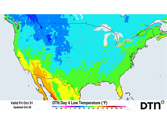
At the end of October, many areas of the United States have already seen their first frost. Some areas in the far north saw freezing conditions in early September while others in the Central Plains and Midwest have had it occur at various times throughout October. The South is looking to take its turn this week behind a strong cold front moving through the country.
The system responsible is not taking a traditional path across the U.S. Typically, we see a low-pressure system in the north with a front that sweeps across the country to its south. And with a front moving into the Northern Plains on Monday, we would expect that front to then sweep across the country, bringing lower temperatures behind it.
P[L1] D[0x0] M[300x250] OOP[F] ADUNIT[] T[]
However, this one is different. A low-pressure center is forming in Oklahoma and Texas on Oct. 28, on the southern end of the front. That will become the dominant low, which is forecast to move across the Southeast on Oct. 29, then take a turn northeast, moving through the Northeast U.S. for Oct. 30-31. The old portion of the cold front to the low's north has stalled, which is producing showers from Minnesota into Missouri for Tuesday and Wednesday.
With the main low-pressure center then over the southern tier of the country, the cold air moving down the Plains will then sweep down toward the Gulf and across the Southeast during the next few days, instead of pushing through much of the Midwest.
To go along with some breezy winds, where gusts could exceed 45 miles per hour across Kansas, Oklahoma and Texas, the cold air will be the first real shot of fall-like air for many areas from Texas to Florida. Morning low temperatures during the next few mornings may make it down to the freezing mark as far south as northern Texas on Wednesday and Thursday, and across northern Mississippi, Alabama, and Georgia on Friday and possibly Saturday. Portions of the Carolinas up through the Northeast will see frosty mornings for the first couple of days of November. Freezing conditions are not forecast within about 250 miles of the Gulf. These areas will have to wait for another burst of cold air to move through the country.
The date of the first frost is quite variable for the southern tier of the U.S., which may come in late September or possibly not until early December. But for the southern areas expected to see a risk of frost this week, the average date is typically around the end of October or early November, being close to on-time for this year.
To find more weather conditions and your local forecast for free from DTN, head over to https://www.dtnpf.com/…
John Baranick can be reached at john.baranick@dtn.com
(c) Copyright 2025 DTN, LLC. All rights reserved.

Comments
To comment, please Log In or Join our Community .