



Ag Weather Forum
Promising Rain Forecast for Corn Belt Through Mid-August
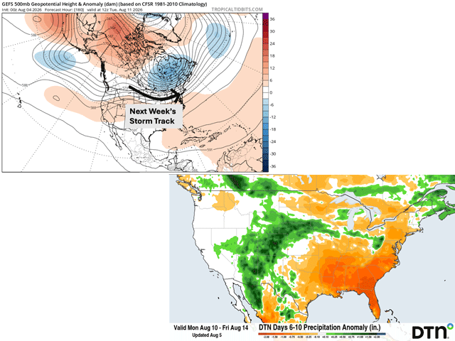
August started out on a high note across a decent portion of the Corn Belt. Between July 30 and Aug. 2, a swath of 2-4 inches of rain extended from northeast South Dakota into central Indiana. Recent rainfall has kept crop conditions steady as corn and soybeans enter critical stages of growth and next week's weather pattern could prove beneficial as well.
In this week's USDA Crop Progress Report, released on Aug. 3, the percentage of soybeans rated in good condition was unchanged at 52% from last week's report. Corn rated in good condition slipped slightly in this week's report, coming in at 48%, compared to 50% last week. Both corn and soybeans are in critical growth stages right now and water will be a timely component to achieve top yields.
For those farmers relying on rain rather than irrigation, corn going through its dent stages requires about 1.3 inches of rain per week to maintain adequate test weights, according to Purdue University. To read more about July and August corn water needs, you can visit: https://extension.entm.purdue.edu/….
P[L1] D[0x0] M[300x250] OOP[F] ADUNIT[] T[]
Water is critical to corn right now, but soybeans also need adequate water during their fill stages. According to Pioneer Seeds, during the early pod fill (R5) to full pod (R6) growth stage, the soybean plant uses about 0.25 to 0.33 inches of water per day, highest during R5. More information about soybean water use can be found here: https://www.pioneer.com/….
During the growing season, soybeans can use around 20-26 inches of water compared to corn, which requires about 21-28 inches.
Luckily, more rain is forecast to hit the Corn Belt through the rest of this week with a slow-moving cold front drifting southeast. On Tuesday it was draped across Nebraska, Iowa, and Wisconsin. By Wednesday and Thursday it will extend into Kansas, Missouri, Illinois, northern Indiana, and southern Michigan. While this front is not expected to bring widespread flooding rainfall throughout the Corn Belt, it could still produce some localized heavier rainfall near 3-4 inches for east-central Missouri and west-central Illinois through Thursday morning.
Looking ahead to the upcoming weekend and next week, rain chances remain steady across the Corn Belt. Another cold front will push into the northwest Midwest Friday and Saturday, leading to light and spotty showers across Minnesota and Wisconsin. The next system arrives on Sunday in the Dakotas, quickly advancing into the Great Lakes by Monday. A front may linger across the Corn Belt next Tuesday and Wednesday, providing some heavier showers and storms to the Ohio Valley.
By next Friday, both the European and American GFS models are agreeing that the heaviest rain next week will fall across southeast Iowa, Illinois, Indiana and Ohio. Two to 3 inches of rain are forecast across Indiana and Ohio by next Friday with totals closer to 1-2.5 inches across Illinois, southern Wisconsin, northeast Missouri and southern Iowa.
While rainfall over 2 inches may be more hit or miss, there is still a high likelihood that quite a few farms across the central and eastern Corn Belt see at least 1 inch of rain by next Friday. The active pattern is certainly favorable for filling soybeans and corn going through its dough (R4) and dent (R5) stages right now. Consistent rainfall through the first half of August could be the key factor to corn and soybeans reaching the top end of their yield potential before reaching maturity.
To find more weather conditions and your local forecast from DTN, see https://www.dtnpf.com/….
Teresa Wells can be reached at teresa.wells@dtn.com
(c) Copyright 2026 DTN, LLC. All rights reserved.