


Canadian Prairies Weather Outlook
Heavy Rain for Canadian Prairies This Weekend Likely Extends Into Next Week
Seeding progress in the Canadian Prairies has likely been rapid this week. After a slow start due to some cold and wet conditions, temperatures have risen well above normal and the combination with a drier stretch of weather has likely gotten planters to be rather widespread across the region.
Even so, progress may still be behind schedule, as noted from this week's report out of Manitoba that still had progress both behind last year and the five-year average. Although conditions have been good this week, that window is closing with another large system moving into the region this weekend.
The storm is not too far away. It is currently spinning around the Great Basin in the western United States and has been for most of the week. That system has been blockaded from advancing by a strong upper-level ridge whose axis is located over Manitoba and far western Ontario. That ridge has allowed for the extreme rise in temperature as many areas have reached above the 30-degree Celsius (86-degree Fahrenheit) mark multiple times this week, with some areas reaching up toward 35 C (95 F). The turn to heat has dried out a lot of fields, allowing for some good fieldwork.
P[L1] D[0x0] M[300x250] OOP[F] ADUNIT[] T[]
Spotty showers have developed at various times this week, primarily in Alberta, but it has been drier for more areas, allowing for more time in the field to advance seeding and other fieldwork. However, the combination of hot and dry conditions has led to some areas getting too dry. Much of Alberta and western Saskatchewan fall in that category and would like to see some rain returning to the region. Spotty showers continue for May 28-29 but will be increasing as the U.S. system finally makes a move this weekend.
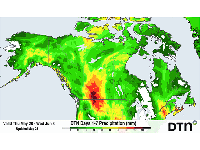
The storm will move into the U.S. Northern Plains on May 30. In doing so, it will send large areas of moisture up through the Prairies, especially across western Saskatchewan and Alberta. Because of the upper-level ridge blocking up the pattern, the storm system will slowly spin through the Northern Plains and into the Canadian Prairies on May 31 and extend its stay into early next week. Models have recently slowed down its eastward progress by a couple of days, which may take until June 3 or June 4 to finally leave the region. That will result in multiple days of showers and thunderstorms littering the Prairies.
Rainfall amounts will depend on thunderstorm development and positioning of a few heavier bands, but much of Alberta and western Saskatchewan are in line to be in the 30- to 60-millimeter (1.2- to 2.5-inch) range by the time the system leaves the region next week. Parts of Alberta will likely see more than that and it would not be surprising to see some areas reaching over 100 mm (about 4 inches) in the southern and central districts up against the Rocky Mountains. Eastern Saskatchewan and Manitoba should see less as a region but are likely to be in the 10- to 30-mm (0.4- to 1.2-in) range with some pockets of heavier rain where thunderstorms are a little more consistent.
That amount of rainfall will do wonders for bringing in good soil moisture but could lead to some flooding in the west. In addition, areas that see heavy rain will see their seeding window close for a while into early June before soils become dry enough to work again, further delaying seeding progress. If producers have not been able to complete their tasks before the rains get heavy this weekend, then significant delays into June may occur, which would be a concern for production.
This rainfall is likely to be needed as well. During a building El Nino, like we are currently experiencing, there is a higher tendency for the Canadian Prairies to be drier and hotter than normal during the summertime, as the storm track is more likely to go south. The correlation is not as high as the milder and wetter conditions over the U.S., leaving some uncertainty, but the risks for expanding drought this summer are real.
To stay up to date with weather conditions and your local forecast for free from DTN, head over to https://www.dtnpf.com/….
John Baranick can be reached at john.baranick@dtn.com
(c) Copyright 2026 DTN, LLC. All rights reserved.