
South America Calling
Clarifying South America's Rainfall Forecast Through Early Next Week

DTN Ag Meteorologist John Baranick wrote about the stark model difference in forecast rainfall across Argentina last week and I wish I could say there were improvements in these differences. For much of this week, the European ECMWF model and American GFS model haven't been able to agree on just how much rain will fall across central Argentina into southern Brazil over this coming weekend and early next week.
Typically, as a weather system gets closer to occurring, weather models come into more alignment on how the system will evolve and the impacts it will produce. It has been interesting to compare the ECMWF and GFS this week. The ECMWF has been painting a swath of moderate to heavy rainfall from the province of Cordoba into Santa Fe and northern Buenos Aires. Rainfall totals from Jan. 17-19 come in around 20-40 millimeters (0.80-1.5 inches) with isolated higher amounts near 50 mm (2 inches). On the other hand, the GFS shows rainfall totals closer to 10-20 mm (0.4-0.8 inches) with isolated higher amounts near 30 mm (1.2 inches).
When comparing the GFS and ECWMF to what they were outputting last week, there's almost a complete reversal. The ECWMF was showing 10-20 mm (0.4-0.8 inches) while the GFS came in higher at 20-30 mm (0.8-1.2 inches). With the ECMWF showing an increasing trend in rainfall, the GFS has shown a decreasing trend; therefore, it might be confusing which model to believe. Luckily, meteorologists have a few more tools in their hands to decipher why models may be doing what they are doing, and which model seems to have a better handle on how the system may evolve.
P[L1] D[0x0] M[300x250] OOP[F] ADUNIT[] T[]
One aspect meteorologists can take into mind when forecasting precipitation is knowing what's happened in the past. For the last few weeks, precipitation has been below average across the main growing areas of Argentina and southern Brazil. Over the past 15 days, observed rainfall has reached 30-50 mm (1.2-2 inches) in Cordoba, but rainfall amounts drop off substantially toward Santa Fe and northern Buenos Aires, where they've only managed to receive less than 20 mm (0.8 inches). With drier-than-normal conditions in place, there's likely some dry air that this weekend's system will need to overcome. When a developing storm begins moving into an area that has had persistent dry air, some of the initial precipitation may outright evaporate before hitting the ground.
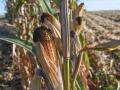
With this in mind, I'm hesitant to fully rely on the ECMWF model, but I think the GFS is too low. It's not all that uncommon to use a blend of the two models; therefore, total rainfall may be closer to 15-30 mm (0.60-1.2 inches) across Cordoba, Santa Fe and northern Buenos Aires. These rainfall amounts are likely to provide some benefits to their developing corn crop, however, precipitation of this magnitude needs to take place more often.
The situation doesn't look much different in southern Brazil. The system that moves through Argentina will start to enter southern Brazil on Jan. 19 and linger through Jan. 20. Much like Argentina, they've been dealing with below-average precipitation over the past 15 days. DTN is forecasting rainfall to remain around or less than 20 mm (0.8 inches) across western Rio Grande do Sul. In the state of Parana, just to the north of Rio Grande do Sul, rainfall will be closer to 30-50 mm (1.2-2 inches) with isolated higher amounts near 75 mm (3 inches).
Only temporary relief to the recent dry conditions is likely with the system that passes through Argentina and southern Brazil over the next few days. Model guidance provides another stretch of dry weather next week and temperatures aren't expected to drop too far below average either. Both soybean and corn ratings may slip even further with widespread above-average precipitation looking unlikely, and only a brief period of below-average temperatures before temperatures near 30-35 degrees Celsius (86-95 degrees Fahrenheit) return.
To find more international weather conditions and your local forecast from DTN, visit https://www.dtnpf.com/…
Teresa Wells can be reached at teresa.wells@dtn.com
(c) Copyright 2025 DTN, LLC. All rights reserved.