

Ag Weather Forum
Huge Spring Storm Starting Sunday Will Bring Heavy Snow, Strong Winds, Freezing Rain, Severe Weather Threat
Heavy snow is expected across the Northern Plains and Upper Midwest on Sunday through Tuesday, March 24-26, with the heaviest snow falling on March 24.
By Saturday night, the National Weather Issue already had issued winter storm warnings and other winter advisories and watches from Montana to Wisconsin and into Nebraska.
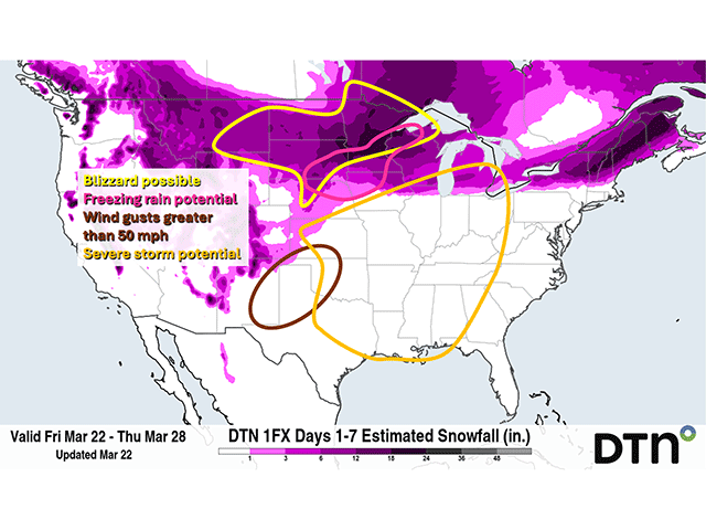
The quickly deepening storm system will wrap around a shield of mostly snow that should fall heavily Sunday and Monday with weakening as the system pulls northeast Tuesday. Snowfall amounts are still being determined, but as of Friday the forecast from DTN estimated snowfall amounts of over 6 inches in a wide area from Montana through northern Wisconsin and the Upper Peninsula of Michigan with amounts over 12 inches across the eastern Dakotas, much of Minnesota, and northern Wisconsin. The western mountains will also receive some heavy amounts.
Near the edges of the snow, some freezing rain may develop as well. This is most likely across southeastern South Dakota and into Iowa on Sunday through Tuesday possibly mixed in with rain and snow from northeast Nebraska into northwest Wisconsin on Sunday.
To go along with the snow, strong winds will be developing around the low center. Though the winds may not be extreme where the snow is falling, wind gusts of 40-50 mph will be strong enough to cause blowing and drifting of the snow as well as blizzard conditions.
Farther south across the Central and Southern Plains, wind gusts may be a bit stronger as they downslope off the Rockies with gusts of 50-65 mph possible on Sunday, being strongest in the southwestern Plains from New Mexico through west Texas and into western Oklahoma.
High winds from the central to Southern Plains has triggered warnings, including concerns of critical fire weather conditions. Red flag warnings were already issued on Saturday night for parts of Kansas, Colorado, Oklahoma and Texas.
P[L1] D[0x0] M[300x250] OOP[F] ADUNIT[] T[]
Gusts away from this zone may only be in the 40-50 mph range that matches the north, but still enough to cause some damage as well as blow dust from drier soils in parts of this region.
The dynamic storm system should also produce some severe storms. Though that risk is still being assessed, the Storm Prediction Center is currently targeting Kansas and Oklahoma on Sunday and the Lower Mississippi Valley on Monday with having the greatest chances. We may see these areas expanding northward in future updates and could include portions of the eastern Midwest and Southeast for Tuesday.
To see more on the DTN weather forecast, see the video at https://www.facebook.com/…. DTN Weather Risk Communicator Nick Lesser explains the anticipated progression of the system across the upper Midwest and its impact on the potential for elevated outage predictions in the region into the week ahead. Also check https://www.facebook.com/… during the week ahead for updates.
While the winter storm, with its blowing snow and low visibility, will cause dangerous travel conditions, the storms bring welcome precipitation.
As explained in an earlier DTN article, https://www.dtnpf.com/…, significant soil moisture and rainfall deficits continue to exist across a lot of the middle of the country, even through a fairly active pattern during the winter.
With how warm it has been, most of this moisture, even the portion that falls as snow, will readily soak into soils and help to fill them up. The Upper Midwest, and specifically Iowa and Minnesota and adjacent areas will see some significant precipitation approaching 2 inches of liquid equivalent out of this storm system. Though it may come with some short-term headaches and potential damage, this storm could be more beneficial than detrimental, especially when it comes to the ag sector.
This will not be the only strong storm system to move through during the next couple of weeks. At least two more storms will move through later this upcoming week and weekend on the current forecast, a chance to add more moisture in before spring planting and give some additional rainfall to the southwestern Plains, which may miss out on a lot of this heavy precipitation.
As for what is triggering this change in patter, it's caused by El Nino weakening in the Pacific Ocean, bringing colder air down from northwest Canada. In turn, that is sparking some frequent springtime storm systems -- including this one starting this weekend and into early next week which may end up being the strongest of the coming storms -- because all the ingredients are there.
This includes deep arctic cold, warmth further south, access to Gulf of Mexico moisture and strong upper-level dynamics.
The setup actually began away from the coming storm system. An upper-level ridge built itself up over western North America and especially into Alaska this past week, which is driving colder, Arctic temperatures through much of Canada and the Northern Plains as temperatures dropped well-below normal.
At the same time, it has been very warm across the southern tier of the country and temperatures were forecast to rise going into the weekend. The clash between the Arctic cold and springtime warmth fuel the big system that came from a trough off the West Coast on Friday.
The storm traveled quickly through the West on Saturday and arrives in the Central Plains by early Sunday. The pull of moisture from the Gulf of Mexico will fuel widespread precipitation near and north of the low into the Arctic air. As the cold front in the system moves into the Plains, thunderstorms, likely becoming severe, will develop as well. The storm itself will get pulled apart early next week, with the main low moving up toward Hudson Bay by March 28 while the cold front to the system should slow down as it moves east, losing access to the main upper-level support. Still, this storm should produce widespread impacts from the precipitation and winds circulating around the system.
To find more weather conditions and your local forecast from DTN, head over to https://www.dtnpf.com/…
John Baranick can be reached at john.baranick@dtn.com
(c) Copyright 2024 DTN, LLC. All rights reserved.