

Low Water Impacts on Mississippi River
Navigation Pinch Point on Mississippi River Moves North
OMAHA (DTN) -- The pinch point for navigation on the Mississippi River has moved upstream from Memphis, Tennessee, to St. Louis as the Army Corps of Engineers starts to reduce flows from the upstream Missouri River dams this weekend.
Lower water flows coming from the Missouri River will lead to longer dredging operations on the Mississippi River around St. Louis to keep a navigation channel open.
Barge movements remain slow, but the New Orleans area grain terminals last week reported a 35% increase in barges they were able to unload compared to a week earlier, according to a weekly USDA report.
Brad Rippey, a meteorologist at the USDA Office of Chief Economist, said Friday on a webinar that spot barge rates have dropped from $110 a metric ton in October down to closer to $40 a metric ton now. The rate had run at $20 a ton for much of the year.
For farmers, Rippey said this has translated to some producers on the lower Mississippi River receiving $2 less per bushel for both corn and soybeans.
"We started seeing these big spikes in the cost of moving agricultural products downstream, and that has led to some of these spot prices going up to $2 to even over $3 (less)," Rippey said. "So that's really cutting into the profit margins for some of these producers."
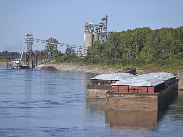
Barges have been pinched by the shallow drafts. The barges themselves are carrying about 30% less to meet a 9-foot draft, and the tows are moving fewer barges because of the narrow channel. Tow operators that would normally move 45 barges are now restricted to 35 southbound and 25 northbound.
"It presents a certain challenge trying to find the navigation channel," said Paul Rohde, vice president of government affairs for the Waterways Council Inc., which advocates for the inland waterway operators. Rhode described the situation as, "I'd say right now we have got a stabilized crisis."
Rhode added the economic costs of a shallow Mississippi River might be hard to quantify, "but the impacts are in the billions of dollars."
At its slowest point in October, barge movements on the Mississippi River dropped from a three-year average of 700 barges down to closer to 150 barges. Tonnage fell from 1 million metric tons (mmt)a week down closer to 150,000 metric tons (mt).
P[L1] D[0x0] M[300x250] OOP[F] ADUNIT[] T[]
SHALLOW ST. LOUIS
On Saturday, the Army Corps of Engineers upstream on the Missouri River will reduce water releases from the lowest dam on the Missouri River -- Gavins Point, South Dakota.
Gavins Point had been averaging about 30,000 cubic feet per second (cfs) but the Corps is starting to dial back water releases and will bring it down to the minimum level of 12,000 cfs. The Corps will start stepping down water releases about 3,000 cfs per day until early December.
As DTN has reported, the Army Corps of Engineers on the Missouri River is not authorized to change water releases to support the Mississippi River.
By the end of November, that drawdown on the Missouri River will drop the Mississippi River levels about 3 feet at St. Louis, and lower until the Mississippi River gets closer to Cairo, Illinois.
That lower flow from the Missouri River will force dredging operations in the middle section of the Mississippi River. Dredging, which can halt barge traffic, operated on a 12-hours-on, 12-hours-off schedule to allow navigation during that time. Col. Andrew Pannier, Corps deputy commander in Mississippi Valley Division, said extreme conditions expected in early December could lead to extended dredging hours ranging anywhere from 24 to 72 hours before the navigation can start again.
"We remain confident that our dredging operations will keep the river operating at a 9-foot depth in the channel," Pannier said.
GRAIN AND BARGE MOVEMENT
Combined, corn and soybean shipments on the river systems, including the Illinois and Ohio rivers, for 2022 are just over 26 mmt, down about 12.5% from the same year-to-date in 2021.
For the week ending Nov. 12, USDA's Grain Transportation Report showed total grain shipments on the inland waterways at 592,000 mt. That was 7% lower than a week earlier and 33% less than the same week a year ago.
At the same time, 830 grain barges unloaded in the New Orleans port terminals, a 35% increase from last week's numbers.
During the last month, soybean shipments down the river system have hit 132,000 mt, about 96% of last year's volume during the same four-week stretch. Corn shipments down the river system during the past month are just at 58% of last year's volume.
Total grain export inspections at the Mississippi Gulf equal about 95% of last year's volume, according to USDA. Corn, soybeans and wheat total 55.17 mmt in the Mississippi Gulf, compared to 57.85 mmt last year.
Overall, USDA numbers show the Mississippi Gulf grain inspections for exports are closer to hitting last year's volumes than the Pacific Northwest at 81% of last year's volumes and the Texas Gulf at 73%. Interior exports are at 96% of last year's volume.
See "No Help for Mississippi From Mighty Mo,"
Also, "Mississippi River Mayors Call for Federal Drought Aid Over Low River Conditions,"
USDA Grain Transportation Report for Nov. 17 https://www.ams.usda.gov/…
Chris Clayton can be reached at Chris.Clayton@dtn.com
Follow him on Twitter @ChrisClaytonDTN
(c) Copyright 2022 DTN, LLC. All rights reserved.