

Ag Weather Forum
Cold Front Brings Brief Heat Relief and Showers This Weekend, Drying Out Next Week
Last week, much of the country got a break from the high heat that has had a pretty strong grip this summer. Not everyone would agree that occurred, especially if you live in Texas, which remained hot. But in general, much of the country east of the Rockies saw near- or below-normal temperatures for this time of year. The southern end of the country's growing regions also saw more rain falling than they likely have seen most of the summer. Areas of flooding occurred with some significant reports out of the St. Louis area as well as in Illinois and eastern Kentucky, where several deaths occurred. But other areas from the Texas Panhandle east to the southern Appalachians saw moderate to heavy rainfall over the past week. Many of these areas are in drought or have been in and out of drought all season and appreciated the respite from heat and dryness. The Drought Monitor update scheduled for Thursday, Aug. 4, is likely to show improvements for many of these areas.
But that break was brief and the large ridge of high pressure in the upper atmosphere that produced record heat in the Pacific Northwest last week has spread throughout most of the U.S. this week. That brought heat back into the middle of the country, which at times will extend eastward for the next week. The pattern is not without some benefit, however, as several disturbances will ride over the top of the ridge through Canada and bring their cold fronts through the Corn Belt.
Rain will be harder to come by in the Northern Plains, but as these fronts move southeast, they will pick up more moisture and produce more widespread precipitation, especially along and east of the Mississippi River. We have seen this dichotomy play out before with a hot-and-dry west and a mild-and-wet east, like the summer of 2021. But of course, this year has little resemblance to last year, overall.
P[L1] D[0x0] M[300x250] OOP[F] ADUNIT[] T[]
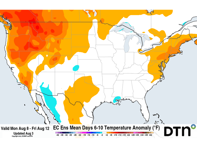
With all the recent heat and forecasts of a hot and dry August, we should remind ourselves even though the entire month may average out to be hotter than normal and drier than normal in most areas between the Rockies and the Appalachians it does not mean that there is no variability in that forecast. Like I wrote last week here, https://www.dtnpf.com/…, we could see a break in this hot, dry pattern shaping up around the middle of the month. While a front moving through the Corn Belt Aug. 3-4 does not have much cold air to work with, it is producing marginally moderate rainfall as it works southeast. Another front coming through this weekend across the Northern Plains will have access to much cooler air, bringing temperatures down below normal for a couple of days. Temperatures will moderate as the front sweeps through the rest of the country early next week, but more seasonable temperatures either side of normal are forecast.
Much like the trough that moved through the eastern portions of the country last week, the one coming up will be brief. After a few days of some cooler temperatures, readings will rise above normal again for the Plains. Temperatures may remain milder to the east. But the trough moving in will clear out a lot of the humidity in the air and lead to a period of dryness behind the front that will likely last through the rest of next week.
Precipitation and soil moisture are very important this time of year as corn and soybeans are busy filling kernels and pods. While a drink might be nice, soil moisture has declined in a lot of areas of the Corn Belt and, specifically in the west, despite some recent rains. More moisture is going to be needed to fill out seeds. And the prospect for higher temperatures coming back into the Plains will not be helpful. While the weather has been nothing like what occurred in 2021, we may see some similarities showing up between the hotter and drier west and the milder and wetter east, of course with many caveats due to local conditions.
All the weather events this year have made for a variety in crop health, conditions, and yield potential for corn and soybeans. It will be interesting to see how yields are looking across the major production states in the Corn Belt when the DTN Digital Yield Tour powered by Gro Intelligence results are released next week. You can find more about what that process looks like here: https://www.dtnpf.com/….
To find more regional weather conditions and your local forecast from DTN, head over to https://www.dtnpf.com/…
John Baranick can be reached at john.baranick@dtn.com
(c) Copyright 2022 DTN, LLC. All rights reserved.