South America Calling
Heavy Rain Easing Flash Drought in Argentina
It has not been a very good couple of weeks of weather for Argentina's primary growing areas. The rains shut off in late January and then heat built in for early February, creating a flash drought for most of the country.
A flash drought occurs when drought conditions and effects rapidly develop over the span of a week or two. Sometimes the effects of flash drought can be disastrous. Those who live in the U.S. Midwest experienced flash drought in the late spring and early summer of 2023 and crops did not look good at that time.
The stage of development Argentine corn and soybeans are going through would equate with a general timeline around mid-July in the Corn Belt and those who live there know how detrimental a dry period can be during that time.
P[L1] D[0x0] M[300x250] OOP[F] ADUNIT[] T[]
A lot of Argentina's crops are in their reproductive stages of growth. According to the Buenos Aires Grain Exchange's (BAGE) most recent report on Feb. 8, corn was 56% tasseling and 43% silking with another 19% of the crop filling. Soybeans were a little farther behind with 35% setting pods and 6% filling.
Still, that is a large portion of the crop in a vulnerable state. However, these crops have good root systems and can tap into better soil moisture further down, which built up over recent months. Younger crops cannot do this and pictures from BAGE in that report show some pretty poor-looking corn and soybean fields.
Soil moisture is the main concern as it has fallen like a rock over the last two weeks. With no rain to add to it and temperatures nearing or exceeding 40 Celsius (104 Fahrenheit) all last week, that should come as no surprise. BAGE estimates 40% of the corn and soybean acreage is currently in drought, which is up from single digits just two weeks ago. The rapid decline in soil moisture is a major concern, but luckily for those in the region, rainfall has been increasing this week.
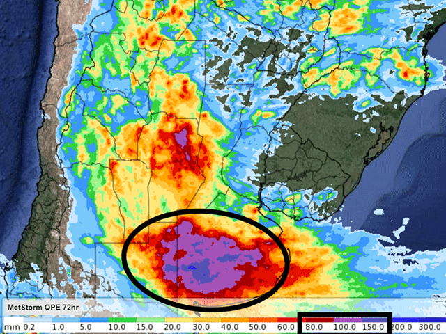
A front moved into southern areas late Tuesday and Wednesday, Feb. 6-7, and rainfall amounts of 30-60 millimeters (1.2-2.4 inches) have fallen in the last couple of days. In fact, the driest areas of the region, southern Buenos Aires and northern La Pampa, have fared even better with widespread rainfall over 100 mm (about 4 inches). Some localized areas have been estimated to have seen more than 150 mm (about 6 inches) in Buenos Aires. And more rain is coming.
The front has not really moved the last two days but will be spreading showers northward through the country through the weekend. Another front will move north through the country Feb. 12-13 with another widespread shot of rain and showers may linger at times throughout next week. Additional rainfall amounts of 50-100 mm (about 2-4 inches) appear likely in most areas, though those that have already seen the heaviest rain in the far south are likely to see amounts below 50 mm. After the flash drought situation that has arisen, flooding is now a minor concern. But the crops will generally take it after the harsh conditions of the last few weeks. Soil moisture levels will undoubtedly rise significantly in BAGE's report next Thursday.
Damage has occurred from the flash drought but those conditions are not expected for the next few weeks as more systems are lining up in the Pacific to bring waves of showers through on a semi-regular basis until the end of the month. How much damage and yield loss has occurred is unknown, but it is likely to show up in further crop estimates out of the country and from USDA in the next few months.
To find more international weather conditions and your local forecast from DTN, visit https://www.dtnpf.com/….
John Baranick can be reached at john.baranick@dtn.com
(c) Copyright 2024 DTN, LLC. All rights reserved.


Comments
To comment, please Log In or Join our Community .