

Ag Weather Forum
Heat Returning to Central US?
The stress about the weather has eased for most of the country during the last several weeks. Outside of a brief heatwave in late July, the pattern has favored multiple disturbances, areas of heavy rain, and generally mild temperatures during the most critical time for both corn and soybeans. This change of conditions has fueled a resurgence in the yield forecasts on the DTN Digital Yield Tour. You can read about the general synopsis and national numbers here: https://www.dtnpf.com/….
That hiccup in late July put fears back into this year's crop not only because of how expansive the heat was, and how intense it was, but also because there is little subsoil moisture to depend upon if the heat did not also come with rainfall. Even with the good rainfall pattern since then, there still remains a lack of subsoil moisture for most of the country. That is part of the reason why large sections of the Corn Belt are still in some category of drought despite a more favorable period of rainfall.
This week has been fairly active already as the upper levels have just let any and every little disturbance just pass through the U.S. and southern Canada with little to stop them. A string of disturbances has lined up and will continue to pass across, going into early next week.
There will be a slight change to the pattern next week. A ridge will develop off the Pacific Northwest coast that should create a sort of block from any disturbance going through the central Rockies. But it will have no real effect on disturbances moving through southern Canada. There may not be as many disturbances and systems moving through next week, but there will be a couple of them and they could bring some heavier rain through some areas still. Temperatures will still be on the milder side.
P[L1] D[0x0] M[300x250] OOP[F] ADUNIT[] T[]
Southern areas of the country, namely Texas and the immediate Gulf Coast, have not enjoyed the same active and cooler pattern that areas off to the north have. Instead, a ridge there has kept the heat on.
Daily high temperatures well into the 90s and often over the century mark have baked soils dry there and drought has been increasing. The ridge has been and will be suppressed for the next 10 days but that, too, will change.
As the Pacific Northwest ridge retrogrades westward into the Gulf of Alaska or farther west, the pattern over Canada will more zonal, with small disturbances instead of larger ones that would keep a trough in place.
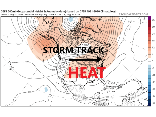
That will allow the southern ridge to expand northward starting around Aug. 19-20. Models have the ridge expanding through most of the Central U.S. including much of the Plains and Midwest. Its movement will expand heat farther north again but also shift the storm track farther north. This appears to be much in the same way the heat ridge developed in late July. Widespread heat should flow through much of the Corn Belt yet again while drying out the southern Belt.
Luckily this time around, the southern end of the Corn Belt has moved past the more critical points of development for both corn and soybeans, but would still have some impact on yields. Areas across the north are still in a critical time period as planting was more delayed there and corn is still prior to the dough stage and soybeans are finally setting pods. The storm track through this area will be more beneficial as it has been a little bit farther to the south recently and many areas have been missed from the northern Red River Valley through Wisconsin.
While many areas to the south have seen the drought reduced either in category on the U.S. Drought Monitor or in impact based on increased precipitation, northern areas have gone the other way, either catching fewer rains or none at all. We would expect that this would be a more favorable pattern for these northern areas going into September.
Models have been hard to trust over this summer as they have done a relatively poor job at getting even the major weather features in the right spot. However, DTN Long-Range Weather Risk Analyst Nathan Hamblin has more faith in this pattern. "Tropical forcing shows a wave going through the Pacific Ocean over the next few weeks. Analogs of this tropical forcing pattern suggest a Central U.S. ridge in place with troughs off of each coast. With models also showing a similar pattern, we can have more faith in their presentation," he said.
Hamblin also noted that though the models are showing a similar upper-air pattern for the end of August and into September, they are different in the specifics. "The European (model) seems to make more sense with the pattern than the CFS at the moment. The CFS is just too dry for northern areas." This is something completely different that we have seen most of the summer. The European model has had a poor record beyond day 10 this season.
To find more weather conditions and your local forecast from DTN, head over to https://www.dtnpf.com/…
John Baranick can be reached at john.baranick@dtn.com
(c) Copyright 2023 DTN, LLC. All rights reserved.

Comments
To comment, please Log In or Join our Community .