

South America Calling
Potential Showers Too Late for Central Brazil's Safrinha Corn
A broken-record dry forecast has been a heart breaker for central Brazil farmers. Dealing with drought since at least mid-April, and in some cases late March, corn production in central Brazil's highest production state of Mato Grosso is struggling to live up to early expectations.
I have written about this quite a bit during the last two months, but early projections of massive records of corn production for Brazil continue to be at risk. In the central states of Mato Grosso, Goias, and Minas Gerais, which make up roughly 60% of Brazil's safrinha (second-season) corn production, the wet season ended more than two weeks early. Early soil moisture was quite good for the crop, likely setting up plants with maximum yield potential. But heat and dryness from mid-March through April have taken the top off of that potential. While production numbers for Brazil have not come down from either the USDA or Conab (The National Supply Company in Brazil), partly due to strong incentive to plant and a large increase in acreage across the country, it is hard to imagine that good weather across the southern states of Parana and Mato Grosso do Sul have made up for the lack of rainfall and poor conditions farther north.
Combined with on-time planting, heat and dryness have pushed corn development into an accelerated pace. According to the Mato Grosso Institute of Agricultural Economy (IMEA), over 2% of Mato Grosso's corn has been harvested as of May 27. On average, the harvest starts the first week of June. This year, it is about two weeks early. With dryness during the last week, the rate of harvest has likely increased. The crop has reached maturity faster than normal and time has largely run out on the crop's ability to use soil moisture or rainfall to boost yield.
P[L1] D[0x0] M[300x250] OOP[F] ADUNIT[] T[]
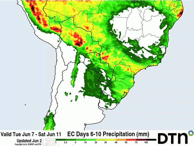
A front has been sitting to the south of central Brazil since last week, teasing the region by bringing showers into Sao Paulo and Mato Grosso do Sul at times. That front will continue to produce showers across southern Brazil and Paraguay through June 7 before it makes a push northward, seemingly waiting for the majority of the crop to reach maturity before bringing in the rains. That is a shame because some rains do look to come to Mato Grosso, and parts of Goias and Minas Gerais as well on June 8-10. Showers will be spotty in Goias and Minas Gerais, but could be more widespread in Mato Grosso, especially across the southwest.
For the portion of the crop that is farther behind developmentally, there could be some stabilization of conditions. The European Centre for Medium-Range Weather Forecasting (ECMWF) model is producing 10-30 millimeters (roughly 0.4 to 1.2 inches) of rainfall in the western half of Mato Grosso. The American Global Forecast System (GFS) model has even more rain, with amounts exceeding 50 millimeters (about 2 inches) across southern Mato Grosso and portions of southern Goias and Minas Gerais as well. If thunderstorms occur, and that is a likely scenario in the tropics, then these higher amounts may be achieved in spots. But with the crop almost mature, it likely will not make a difference for much of the crop this season.
Next week's World Supply and Demand Estimates report from the USDA and Grain Harvest Survey from Conab will be watched to see if the two agencies make any significant changes to their production estimates for Brazil's corn. I am going to assume both agencies would be hard-pressed to do anything but lower their estimates from May.
DTN Lead Analyst Todd Hultman will share his thoughts on the USDA's production estimates for the U.S. and abroad in a webinar shortly after the USDA releases its report on June 10. You can sign up for that webinar here: https://www.dtn.com/…
To find more international weather conditions and your local forecast from DTN, head over to https://www.dtnpf.com/…
John Baranick can be reached at john.baranick@dtn.com
(c) Copyright 2022 DTN, LLC. All rights reserved.

Comments
To comment, please Log In or Join our Community .