
South America Calling
Where is La Nina?

This does not look like La Nina in South America. Though at a technical level we are not in one, we are right on the edge and the designation is likely to become official over in the next couple of weeks. La Nina tends to lead to drier conditions over Argentina and southern Brazil during the spring, while delaying the start of the wet season in central Brazil. Both factors had producers sweating in South America. And while there is certainly time for conditions to change as planting is only partially finished, the effects of La Nina have not been as bad as feared.
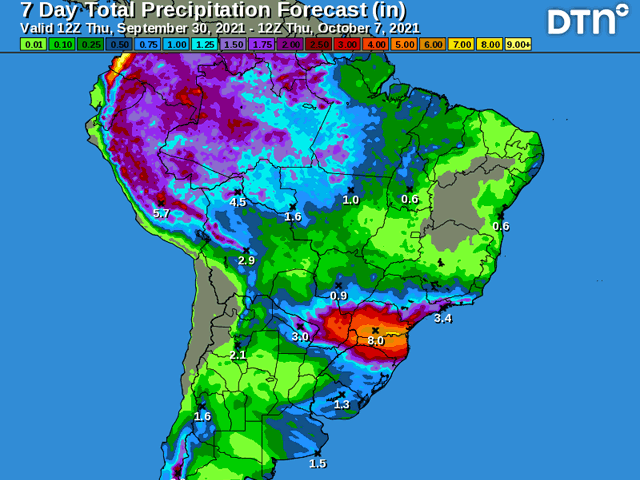
Active weather over Argentina and southern Brazil suggests La Nina is not really having much of an influence thus far. Rainfall amounts in and around Rio Grande do Sul, Brazil, and down to Buenos Aires, Argentina, have shown up to 50 millimeters (up to two inches) of above normal precipitation over the last 30 days. Not all of southern Brazil and Argentina have seen the beneficial rainfall, with pockets of dryness across Parana, Brazil, and Cordoba, Argentina -- two major production areas -- seeing below normal rainfall. But this is not the pattern you would typically expect being on the brink of La Nina.
There is some indication the wet season in central Brazil has been delayed, but that is only a matter of perspective. Scattered showers have popped up every day since at least Sept. 25 across Mato Grosso, Brazil, the country's highest production state for both soybeans and corn. Additional isolated showers have fallen in Goias and Minas Gerais as well as portions of Mato Grosso do Sul and Sao Paulo at times. That would seem to indicate the wet season is underway, or we are seeing the beginnings of it. However, neither rainfall coverage nor amounts have been overly impressive and temperatures have been making runs at 40 degrees Celsius (104 Fahrenheit) daily as well, which has limited some of the impact despite the daily shower occurrences. Many of these areas are reporting below normal precipitation for the month of September.
P[L1] D[0x0] M[300x250] OOP[F] ADUNIT[] T[]
But the threat of La Nina has surely motivated producers in central Brazil to get out and plant soybeans. Last year's event produced disastrous results as delays in planting and emergence of first-crop soybeans pushed back the planting of second-crop corn. I am certain the knowledge of another impending La Nina forthcoming is prompting producers to plant early, even if soils are not yet ready. This sort of decision can cause a couple of issues if it is widespread.
First, with showers still being isolated -- and that seems to be the case through at least the first half of October -- there will be some pockets of mixed emergence across the region. Large corporate farms could have some uneven growth early, which could hinder their plans for management through the season. We would have to see if that has any sort of tangible effect on crop conditions later.
Another issue could present itself by increasing drought stress. Irregular rains may be enough for the crop to germinate, but if showers don't return, dry weather could burn out young seedlings, an effect we saw quite a bit in the Dakotas and Minnesota this past season.
As far as the forecast is concerned, the isolated showers are not going away in central Brazil. The heat remains while moisture continues to spread away from the Amazon. This provides plenty of fuel to produce showers when the upper-level conditions allow. Mato Grosso continues to be the main focal point for showers, but the other states in the region should see some showers as well, even if they are not consistent or heavy.
Storm systems and fronts continue to develop across Argentina, producing scattered showers and moving into southern Brazil with more consistent and heavier showers. That pattern looks to continue with a couple of systems through next week. Planting and germination conditions have been rather good thus far this spring for a lot of these areas, but the scattered showers have left some areas missed and needing more as mentioned above. But overall, conditions are much better than is typically expected during La Nina, including the dry start from last season.
John Baranick can be reached at john.baranick@dtn.com
(c) Copyright 2021 DTN, LLC. All rights reserved.
Comments
To comment, please Log In or Join our Community .