

Ag Weather Forum
Winter Drought Looms for Iowa

Iowa is having a dry fall. Through the first half of November, total precipitation in the state for the meteorological fall season (September, October and November) comes in at 5.l8 inches, nearly 2 inches below the 30-year average.
That dry pattern certainly boosted harvest progress. The Iowa crop progress report issued Nov. 13 estimated the state's corn harvest at 94% complete, 10 days ahead of the five-year average. The soybean harvest is called nearly complete, nine days ahead of the average. Corn moisture is also favorable at 16%, which means the grain needs very little additional drying before going into storage.
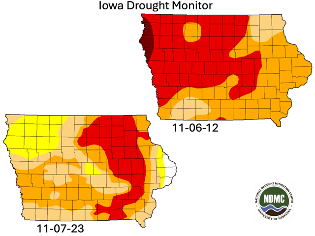
However, those harvest efficiencies come with another side. Iowa is the driest for this time of year since November 2012, a year with historic drought.
P[L1] D[0x0] M[300x250] OOP[F] ADUNIT[] T[]
"Iowa continues to be dry; this is the 177th consecutive week of drought in Iowa (D1-Moderate Drought or worse). The 2012 record was 151 weeks," Iowa State Climatologist Justin Glisan told DTN via email. This fall, Iowa statewide precipitation in October, at 3.12 inches, was 0.43 inches above normal -- the first time in eight months when the state's precipitation total was above the long-term normal.
November's main characteristics are it has been warm and dry. The first half of the month has seen temperatures in Iowa average almost 4.0 degrees Fahrenheit above the long-term (30-year) normal temperature. And a lack of precipitation may post a new historic reference.
"More than 60 National Weather Service co-op stations with a period of record at or above 100 years are having the driest November on record ... with half the month to go," Glisan said. "The western three-quarters of Iowa have yet to see measurable precipitation this month, so a vast majority of Iowa's stations are having a historically dry November."
The extended dryness is showing up in the form of dry soils. Iowa's topsoil moisture is rated 58% short to very short at mid-November. Subsoil conditions are even drier, at 69% short to very short. In other words, less than one-third of the state's subsoil moisture is judged to be adequate to surplus.
Drought forecasts through the next one to three months have varied messages. The U.S. Climate Prediction Center's November outlook indicates continued or deepening drought across Iowa, with some easing suggested during the November-to-January period in the central and eastern sectors of the state. In that same three-month time frame, DTN's seasonal forecast calls for Iowa precipitation to range from 1.5 to 3 inches below normal.
The last time Iowa was this dry (or worse) in 2012, heavy spring and early summer precipitation brought near-total removal of drought by late June 2013. Hopefulness and anxiety about the chances for a repeat of that moisture recharge are likely to occupy many thoughts on both the production and agribusiness sides of Iowa and Midwest agriculture during the end of harvest and the transition to the waiting for and watching of winter.
More details on how El Nino may affect Midwest winter precipitation are available here: https://www.dtnpf.com/….
Bryce Anderson can be reached at Bryce.Anderson@dtn.com
(c) Copyright 2023 DTN, LLC. All rights reserved.
Comments
To comment, please Log In or Join our Community .