

Ag Weather Forum
Early Snowfall Limits Fieldwork in the Northern Plains This Week

The setup for an early season snowstorm was pretty good last week. A ridge across the East and a trough in the West were pretty stagnant features, making for multiple rounds of precipitation for the middle of the country.
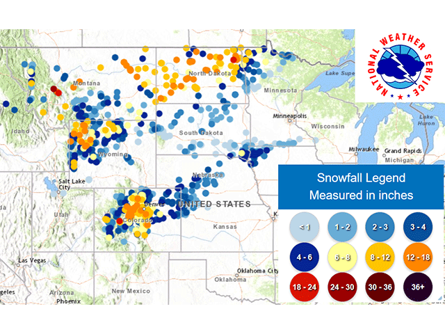
With cold air moving down from Canada throughout the week, it led to areas of snow accumulation in several bands. Large portions of Montana and North Dakota were blanketed by heavy snow around the middle of the week. Streaks of 6-12 inches were common across a wide area of both states though it came in a couple of bursts.
Afterward, another streak fell from Colorado to southern Minnesota during the weekend. The southern band saw much less snowfall on the whole, with only a couple of inches in most places. But heavy snow did fall against the Rockies, where up to a foot was recorded in and around Denver and most of the Colorado front range.
P[L1] D[0x0] M[300x250] OOP[F] ADUNIT[] T[]
Snowfall in late October is not abnormal for this part of the country. In fact, it happens fairly frequently on an annual basis. But the impacts are still annoying for producers in the region. Heavy snow puts a stop to fieldwork; plowing especially but also the remaining harvest. The excess moisture with temperatures hovering around or below freezing can make for some soft and squishy grains that make for a difficult harvest. For livestock producers, it means extra feed for cattle that aren't used to the cold weather yet and need extra energy to walk through the snow or muddy fields as it melts.
The cold that has spread into the region after the snowfall has been significant as well. Temperatures well-below freezing have been a mainstay since late last week and continue for much of this week. Single-digit low temperatures have been observed in western areas of the region as well. That puts a halt to a lot of activities and increases fuel demand. The cold is expected to last longest over the heavier snowpack in the north, and the snow will be slow to melt this week.
Sub-freezing temperatures will stick around as long as the snow does, and likely a touch longer, even though high temperatures will be rising for the latter half of the week. We could even see sub-freezing lows into the weekend across the Central Plains and are almost guaranteed for the Northern Plains. That shouldn't surprise anyone though, as normal overnight lows dip below freezing in these areas anyway.
But it does make it more difficult to be a farmer or rancher in these areas. November is typically a pretty wild month with lots of swings up and down as the atmosphere transitions from summer into winter. The forecast is for plenty of these swings throughout the month. That unfortunately means more chances for precipitation as well.
Later this week and continuing into next week, several smaller disturbances are forecast to move through the region. They may not have a lot of moisture to work with, but they could have enough to be annoying for those that would like to see a stretch of dryness. The northern tier of the country is favored with this through early next week. Waffling temperatures up and down should be expected as these disturbances pass by as well.
If there is any consolation, the forecast for December is for drier and warmer conditions from Nebraska northward as El Nino's influence fully takes hold. That would mean a more southern storm track, which could creep up into Kansas a little more often as well.
To find more weather conditions and your local forecast from DTN, head over to https://www.dtnpf.com/…
John Baranick can be reached at john.baranick@dtn.com
(c) Copyright 2023 DTN, LLC. All rights reserved.
Comments
To comment, please Log In or Join our Community .