
Ag Weather Forum
Argentina Catching No Breaks in La Nina Pattern
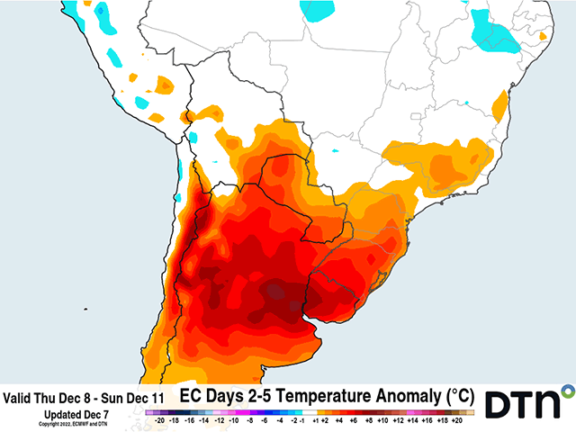
A well-advertised heatwave in Argentina is upon the country. Several days up near 40 degrees Celsius (104 degrees Fahrenheit) have already been recorded this week. Some isolated showers may bring those extreme highs down when they occur, but the risk for more 40-degree days continues through Sunday. A front coming through will clear out the heat thereafter, but it will also leave the country dry next week. With limited moisture, extreme heat, and a return to dryness, crops will continue to find stress for the foreseeable future.
The main growing region from the state of Cordoba to Buenos Aires, commonly referred to as the Pampas region, has had it rough since before the season began. Drought has been in place through most of the calendar year thanks to an extended La Nina episode. Soil moisture has been below normal and devastatingly low for months.
Recent rains have helped in some localized areas, the southern Pampas region in particular, but the improvements in soil moisture have not translated to widespread improvements in crop development or condition thus far.
P[L1] D[0x0] M[300x250] OOP[F] ADUNIT[] T[]
Adding to the pain this week is the heat. On Dec. 5-6, temperatures were up near 40 C (104 F) throughout the region. Showers have so far been limited or non-existent. But a couple of weak disturbances will bring showers to the region Dec. 7 and Dec. 9. However, showers are going to be isolated. Temperatures may fall more into the lower- to mid-30s C (lower to upper 90s F) when these showers occur. But where they do not and clouds do not interfere, high temperatures will again hover near 40 C through Dec. 11. That is a full week of temperatures near that level and will be devastating to local crops.
As I mentioned last week here: https://www.dtnpf.com/…, soil moisture across the region is desperately low. Isolated showers moving through with extremely high temperatures are not going to change that this week. Crop conditions should be expected to fall for next week.
The heatwave will come to an end as a front moves through Dec. 11-12. The front should produce some more organized showers, but models are currently indicating that to come together mostly north of the Pampas region in northern Argentina and into southern Brazil. Temperatures will fall more to seasonable levels for next week. However, the front will also clear out chances for precipitation. Dryness is expected to resume for the country, with a chance maybe at the end of next week as another front moves through. That chance looks better on the American Global Forecast System (GFS) model as opposed to the European Centre for Medium-Range Weather Forecasting (ECMWF) model, but either way looks to occur mostly north of the Pampas region.
Argentina has already gone through incredibly poor growing conditions to start the season. Planting is way behind for both corn and soybeans, and growing conditions do not look to improve during the next two weeks. Severe damage may start to occur if forecasts continue to suggest poor growing conditions into 2023.
For a more extended look at South American weather, join me at the 2022 DTN Virtual Ag Summit Dec. 12-13. Get all of the information you expect from DTN, from the comfort of your home or office. For details on the agenda and how to register, visit www.dtn.com/agsummit
John Baranick can be reached at john.baranick@dtn.com
(c) Copyright 2022 DTN, LLC. All rights reserved.

Comments
To comment, please Log In or Join our Community .