

South America Calling
Break in the La Nina Dryness for Argentina, Brazil
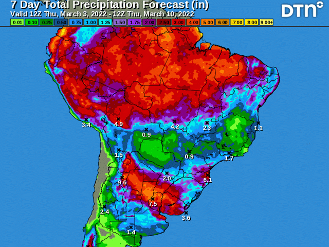
A period of enhanced rainfall has started up across Argentina and southern Brazil since Feb. 26 and is forecast to last through the end of next week or so, around March 13. That flies in the face of what normal conditions have been during the last several months across the continent.
La Nina has caused an incredible imbalance in rainfall this season in South America. The northern half of the continent has seen all the rain it can handle, while southern areas have largely been in drought since the crop year started in late September. Both extremes have caused challenges for the first half of the crop year.
Extreme wetness in the north came from an on-time and aggressive start to the wet season that has rarely let up. Producers have been more concerned about not receiving enough sunlight, along with disease pressure and grain quality in saturated fields, rather than getting enough moisture to produce a crop. What started as an excellent prospect for grain production evolved into concerns about soybean quality and fieldwork conditions. A fast start to the harvest season in January into early February slowed deeper into February due to the wetness.
Safrinha (second-season) corn planting begins immediately following soybean harvest in these areas. At almost 83% complete for corn planting, the state of Mato Grosso, Brazil's largest production state for corn and soybeans, has seen its lead over the average pace shrink from about 18% ahead of the average pace to just 5% ahead. The majority of the crop has been planted in the favorable window, but has fallen from initial expectations a bit due to the delays.
Farther south, drought has decimated large areas of early-planted corn and soybeans in Argentina, and first-crop corn and soybeans in southern Brazil. Production estimates for both have been falling every time a new one is issued by both private and public entities, highlighting the drought concerns that have plagued the region almost the entire season. There have been some rainy periods in there, though. There was one in November, another in mid-late January, and we have entered another one here in early March. But the heat and dryness that has been interspersed between has led to declines in crop production on a wide scale.
P[L1] D[0x0] M[300x250] OOP[F] ADUNIT[] T[]
Crop conditions are suffering in Argentina. According to the Buenos Aires Exchange report that updated March 3, good-to-excellent ratings were a scant 25% for soybeans and 21% for corn. Ratings have been below 40% for both crops since mid-January, despite some decent showers that occurred in late January.
In southern Brazil, producers are hoping that this latest round of showers will turn the tide on the drought. In the state of Parana, which produces 85% of its corn as safrinha, and produces roughly 18% of the total safrinha crop for Brazil, it's sitting in better shape. Some rains in late January, occasional follow-up rains in February have set up plants in better conditions than the first crop. As of Feb. 21, crop conditions for corn were 85% good to excellent, according to the Department of Rural Economics (DERAL) in Parana while only 36% of the crop has been planted. That leaves a lot of the season left to go in this state.
However, as noted in my blog last week, after this period ends, the rest of the month looks more dire for precipitation across most of the continent.
You can find that article here: https://www.dtnpf.com/….
Though yields have already been largely sealed for early planted corn and soybeans in Argentina, and soybeans in Brazil, there will be some benefit to late-planted corn and soybeans in Argentina as they are still flowering and filling. In southern Brazil though, the hope for producers there is that the rains will set the stage better for safrinha corn germination and early growth. According to the forecast, these rains may need to carry the crop for an extended period.
Models have suggested that after a system moves through Argentina March 9-10 and through southern Brazil March 12-13, conditions will go back to their La Nina mainstays of drier south and wetter north for at least the rest of the month and likely through April as well.
However, even the wetter conditions across the north are not expected to be as wet as we normally see during March. Overall, with the high soil moisture across these areas, the dryness in the north is not overly concerning per se, but the risk would be to draw out some of the subsoil moisture instead of adding to it. That risk is amplified a bit when there are concerns that the wet season may shut down early, a typical feature during La Nina.
So, while the current period of rain may offer some benefit, it will not undo the drought that has gripped a large area of arable land in South America, especially when followed by an extended period of more dryness.
To find more international weather conditions and your local forecast from DTN, head over to https://www.dtnpf.com/….
John Baranick can be reached at john.baranick@dtn.com
(c) Copyright 2022 DTN, LLC. All rights reserved.

Comments
To comment, please Log In or Join our Community .