

Ag Weather Forum
Local and Large-Scale Weather Factors Created Illinois Wind Machine

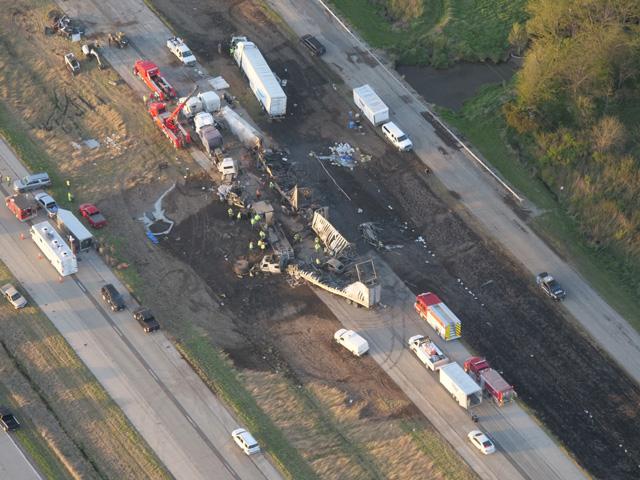
Windy days are not unusual in the U.S. Midwest. Even so, the strong winds which raked blinding dust along a portion of Interstate 55 in central Illinois Monday, May 1, had some features both local and continental that created a wind tunnel. A National Weather Service summary of the dust storm notes: "The dust originated from freshly tilled and planted farm fields and was kicked up by wind gusts of 35 to 45 mph. Winds increased further during the day, peaking at 54 mph at the Springfield airport at 3:42 pm."
Large-scale atmospheric features which were locked in place for several days created the repeated circulation for the strong northwesterly winds. "Westerly to northwesterly winds (45 to 55+ mph) generated by a stalled low-pressure system over the Great Lakes were nearly perpendicular to a major highway (I-55)," wrote USDA meteorologist Brad Rippey.
P[L1] D[0x0] M[300x250] OOP[F] ADUNIT[] T[]
DTN weather risk specialist Nathan Hamblin offered additional context. Hamblin noted the upper atmosphere on Monday, May 1, featured very strong high pressure from the eastern U.S. into the western Atlantic Ocean. In contrast, intense low pressure sat over the Great Lakes. In weather terms, "The [500-millibar] heights in the Great Lakes Region were almost record low for this time of year, over 3 standard deviations below the mean," Hamblin wrote in an email. "At the same time, a trough was coming onshore along the West Coast and squeezed a high over Manitoba. A very impressive pressure gradient resulted, which caused a widespread area of gusty winds across a good portion of the Eastern U.S."
Dryness and the timing of agricultural practices also contributed to the dust storm. "Topsoil was primed to be lofted into the air by short-term dryness," noted USDA's Rippey. "April rainfall in the area totaled about 2 inches, roughly half of normal ... Fields were tilled for planting or had just been planted, leaving topsoil exposed ... By April 30, corn planting was 40% complete in Illinois; soybeans were 39% planted."
The recent dryness also likely contributed to the intensity of the winds through daytime heating on drier ground -- what might be thought of as a local version of the southwestern U.S. Plains dryline. "Dry soils and sunny skies lead to more heating of the surface and increased mixing at the level near the surface. That mixing increases wind speed also," said USDA Midwest Climate Hub Director Dennis Todey.
Big spring dust storms in Illinois have occurred before, but they are infrequent. The Springfield, Illinois, National Weather Service office notes central Illinois dust storm events on May 6, 1983; June 3, 1990; and May 17, 2017. All three events caused some traffic accidents and deaths, but not to the extent of May 1, 2023.
Bryce Anderson can be reached at Bryce.Anderson@dtn.com
(c) Copyright 2023 DTN, LLC. All rights reserved.
Comments
To comment, please Log In or Join our Community .