

Ag Weather Forum
Early Spring Weather Pattern Favors Fast-Moving Storms Ahead
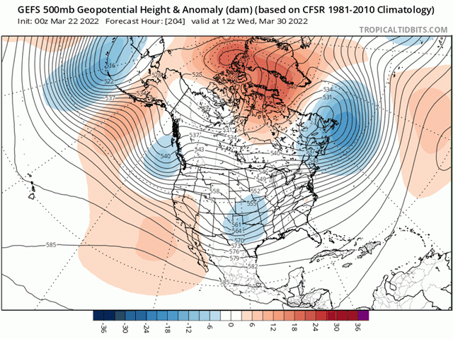
You can call it "progressive" or "zonal" or something else, but the upper-air pattern heading into the last week of March and through the first two weeks of April is going to favor a different type of weather system.
They are not quite Alberta Clippers (moving from Alberta through the Great Lakes) and not quite "Colorado lows" (systems that move from Colorado almost straight east through the Midwest), but overall, we are going to see a pattern change to systems that develop east of the Rockies and move eastward. I am not familiar with a term for them and there may be somebody out there that is. But they should be faster-moving storms developing in Montana or Wyoming and racing eastward through the Great Lakes and southern Canada.
There are no significant ridges of high pressure to block up the pattern for more than a day or two before it moves on. That is why some people call it a "progressive" pattern, whereby weather systems progress rather quickly rather than getting hung up in any one spot. This type of upper-level flow is more west-to-east in its orientation on the whole, which is what the term "zonal" means. You may hear either or both of those terms listening to your local weather forecast for the next couple of weeks.
That is a bit different from the pattern for much of the winter season when an upper-level ridge was anchored over the Eastern Pacific into Alaska that brought Alberta Clippers regularly through the country. Light precipitation across northern zones that sometimes turned moderate or heavy in the eastern Midwest were followed by a wave of cold, arctic air. And it is a bit different than the pattern during the last week where deeper disturbances and troughs moved through the country within a broad and warm ridge across North America.
P[L1] D[0x0] M[300x250] OOP[F] ADUNIT[] T[]
A system this week has been producing pretty hefty precipitation amounts as it draws in moisture from the Gulf of Mexico and slowly pushes northeast across the country.
Severe weather with this storm system should not go unmentioned, as we are now in the severe weather season. This system is following a couple of storm systems from last week that had some similar impacts, especially with regards to rainfall in the Southeast.
Precipitation did improve for drought areas in the Southern Plains this week, but it is not going to last. This new weather pattern is going to favor either storms passing by to the north with little or no precipitation, or those that move west-to-east across the region but with precipitation developing from the center of the Plains and pressing eastward.
Areas closer to the Rockies typically do not see much precipitation as storms leave the Rockies unless the low pressure center passes off to the south. Even with drier air, the mountains force air to rise and can produce some heavy precipitation events, usually snow. That would be more likely to occur from Wyoming northward into the Canadian Prairies under this new regime. Drought in the Southern Plains, especially in west Texas, is likely to grow.
The other factor about these systems coming from more progressive or zonal upper-air patterns is that they do not typically tap into cold, arctic air. That is typically reserved for the Canadian Prairies but not so much in the U.S. The colder air that forces these storms to occur is usually sourced from the Pacific Ocean, which is not as cold as the North Pole, of course. So, while some colder air will undoubtedly work through, the time for Arctic intrusions is essentially over.
With a lot of the snowmelt that has occurred across Canada and the northern U.S. this week, any air masses that are sourced from the Arctic would have less of a bite anyway, and the ever-increasing sun angle in March and April typically washes out any sustained cold air.
However, that does not mean that there are not cold hazards still in play. Progressive or zonal patterns still can still end up on the cold side of normal. While not extreme, that could lead to later-than-normal dates for the last frost. Indeed, the DTN forecast is calling for that to be the case for much of the country east of the Rockies, so those thinking about planting early should be wary of the risks of some replanting potential.
To find more regional weather conditions and your local forecast from DTN, head over to https://www.dtnpf.com/…
John Baranick can be reached at john.baranick@dtn.com
(c) Copyright 2022 DTN, LLC. All rights reserved.

Comments
To comment, please Log In or Join our Community .