

Ag Weather Forum
Tornado Outbreak Possible Later Today for Lower Mississippi Valley
A strong storm system moved into the Southern Plains on Thursday night and produced a band of showers and thunderstorms that brought with it a few reports of large hail and damaging winds.
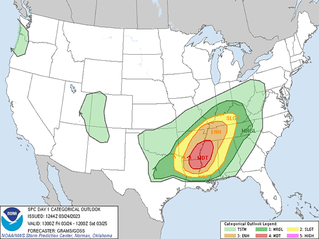
That system will move northeast into the Ohio Valley on Friday, dragging a cold front across the Lower Mississippi Valley this afternoon and evening. The Storm Prediction Center is focused on this area as having a very good risk of severe storms later this afternoon and into the overnight hours across the region. The Center has issued a Moderate risk, the second-highest risk category, for parts of southeast Arkansas, northeast Louisiana, and northwest Mississippi for the significant potential of strong tornadoes and damaging winds.
P[L1] D[0x0] M[300x250] OOP[F] ADUNIT[] T[]
As of early this morning, thunderstorms were located from the Dallas-Fort Worth metro into northwest Arkansas. These are expected to diminish this morning, but could be maintained as the cold front to the system shifts eastward through the morning and early afternoon.
Currently, moisture out ahead of the front is somewhat low, but that will increase the sunshine in the region, building up heat into the afternoon. By that time, increasing moisture coming from the Gulf of Mexico will allow for a newly formed or continued line of storms from northern Arkansas back down through northwest Louisiana, possibly far eastern Texas as well. Weather models suggest that by late afternoon the increasing moisture will also develop discrete cells ahead of the line into western Mississippi. These storms will be in an environment that will be very favorable for supercell thunderstorms and tornadoes and these conditions will be maintained into the overnight period as the cells and trailing line move through Tennessee and into Alabama.
Large hail will be possible, but very strong, damaging winds and long-tracked, strong tornadoes are the main threats today. Please stay weather aware as the storms may pop up violently this afternoon and give little time to react and adjust to the changing weather.
To find updated radar and analysis from DTN, head over to https://www.dtnpf.com/…
John Baranick can be reached at john.baranick@dtn.com
(c) Copyright 2023 DTN, LLC. All rights reserved.

Comments
To comment, please Log In or Join our Community .