



Ag Weather Forum
El Nino Weather Pattern Faces Brief Cold Disruptions
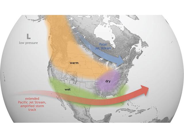
The fall season has been one of active weather from the Southwest to the Upper Midwest. Storm systems coming off of the Pacific Ocean have generally led to a storm track that favored these areas more than the rest of the country. This is heavily influenced by El Nino, the extremely warm waters in the central and eastern tropical Pacific Ocean. With El Nino peaking over the next couple of months, this type of pattern is generally to be expected, though the storm track generally pushes across the southern tier of the country during the winter season.
However, even with this being the strongest El Nino on record, this pattern does see some hiccups every now and then. It will be up to forecasters to find these and point them out, which will be much more important this year than most. Because even when these hiccups occur, they will be unlikely to change the overall El Nino pattern, resulting in brief moments of disruption that long-range models will not be able to see and that short-range models will see too late.
P[L1] D[0x0] M[300x250] OOP[F] ADUNIT[] T[]
Such a disruption is occurring this week as three separate pieces of energy are combining across the eastern half of the U.S. Precipitation is somewhat mediocre from this disruption but will lead to some potential snow in the Northeast and lake-effect showers across the Great Lakes for a few days. The larger disruption is in the temperatures. What has been very warm for the vast majority of the fall will see anomalies peaking at 10-15 degrees below normal from Missouri to the Carolinas and south to the Gulf for a few days behind this system. Anomalies of 5-10 degrees below normal may persist into early next week in a few spots as well. But with how warm it has been, these anomalies will only slightly turn down the overall above-normal anomalies we have seen over the last two months and will hardly show up in maps that feature a full 30 days of temperature anomalies. These are the types of holes that can be poked into the overall El Nino pattern that will have a hard time showing up either when looking far ahead, or far behind when meteorologists reflect on the season as a whole.
But these types of events are memorable and will have effects on local weather, even if it is for a brief time. Temperatures this weekend are forecast to fall below freezing perhaps as far south as the Florida Panhandle. Seasonal maps may show above-normal temperatures for the month of November, but this may be a near or early date for the first frost in some of these southern areas. Folks with sensitive plants could see their crops or plants end their growing season a little early this year.
Finding the next hole in the El Nino pattern will be difficult to do. Weather commenters on social media point toward the displacement of the polar vortex that is currently occurring to have some impact for the next potential in late November or early December. I talked about that a bit in my piece last week: https://www.dtnpf.com/…. Now more than a week later, medium- to long-range models are picking up on some of that potential. Although they are not quite calling for a plunge of arctic air into North America just yet, some models are bringing in chances for below-normal anomalies following a storm system that moves through in the Nov. 20-23 time frame. Temperatures afterward could fall below normal again, but to what degree is highly uncertain. As mentioned in the above piece, any cold air will be fighting against the El Nino base state and will be tough to accomplish. No real source of cold air currently exists in northern Canada, so getting extremely cold air will be difficult. But it could be cold enough to be below normal for a lot of areas, at least for a few days.
More holes in the pattern could shape up for early December, but uncertainty with any short-lived disturbance is extremely low. And like the disruption this week, any breaks from El Nino may not make a huge difference in the weekly or seasonal maps as they are just too brief to give much consideration. El Nino will remain in control of the weather pattern for the next several months, but these disruptions will be important to pick out.
To stay up to date with weather conditions and your local forecast for free from DTN, head over to https://www.dtnpf.com/…
John Baranick can be reached at john.baranick@dtn.com
(c) Copyright 2026 DTN, LLC. All rights reserved.