


Ag Weather Forum
An Early Look at 2027-2028 US Climate Predictions
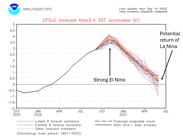
Is it too early to predict the overarching climate pattern across the United States in 2027 and 2028? The El Nino Southern Oscillation (ENSO), which is a broad climate pattern that meteorologists track in the tropical Pacific Ocean, has shown a predictable pattern since the mid-1900s. ENSO has two phases, the warm phase, El Nino, and the cold phase, La Nina. We're in the midst of a very strong El Nino, but which phase will take over in 2027 and 2028?
In early February 2026, above-average water temperatures were noted in the eastern tropical Pacific Ocean. Since then, El Nino conditions have strengthened and across the eastern tropical Pacific water temperatures right now are around 3.7 degrees Celsius (6.7 degrees Fahrenheit) above average.
According to the latest update on ENSO from the Climate Prediction Center (CPC), El Nino conditions are forecast to continue through May 2027. For the U.S., a wintertime El Nino pattern will typically lend to warmer and drier conditions across north-central areas with a wetter pattern in the Desert Southwest and Southern Plains. Drier than average conditions can dominate across the Ohio Valley. The in-depth CPC report can be viewed here: https://www.cpc.ncep.noaa.gov/….
P[L1] D[0x0] M[300x250] OOP[F] ADUNIT[] T[]
DTN's forecast from Dec. 2026-Feb. 2027 calls for temperatures to average near six degrees F above average for the Northern Plains and Upper Midwest while the Ohio Valley will be closer to 2 to 3 degrees F above average. The Southern Plains and Southeast U.S. could see temperatures closer to average. The warmer temperatures in the north could lead to storm systems producing mixed precipitation, including wet snow, freezing rain, or regular rain.
The precipitation forecast for Dec. 2026-Feb. 2027 has precipitation around 2 to 3 inches above average across the Southeast. Across the Southern Plains, precipitation is favored to be around 1 to 2 inches above average. DTN's forecast indicates near-average precipitation across the Ohio Valley and the Northern Plains.
Looking beyond May 2027, the next ENSO phase may become more apparent for late 2027 and 2028. Since 1950, meteorologists have tracked the phases of ENSO and there is a clear pattern that after a strong El Nino phase, La Nina returns for at least two consecutive years. Therefore, by autumn 2027 into early 2028, La Nina conditions could return across the tropical Pacific Ocean.
In order for La Nina to be present, the eastern tropical Pacific needs to have below-average ocean temperatures of at least 0.5 degrees C (0.9 degrees F). When the La Nina phase is present, the general wintertime pattern across the U.S. features more cold air outbreaks in the Northern Plains and Upper Midwest, meaning the Polar Vortex could show up more frequently across these regions. The jet stream, or storm track, could set up across the Ohio Valley and create a wetter-than-average pattern. Farther south, the Southern Plains and Gulf of America Coast may be warmer and drier than average.
To find more weather conditions and your local forecast from DTN, head over to https://www.dtnpf.com/….
Teresa Wells can be reached at teresa.wells@dtn.com
(c) Copyright 2026 DTN, LLC. All rights reserved.